Friday, September 28, 2012

A foggy start

Below you find a link to the fog.....This time of year is really a cool time....When we get cold night time/ealry morning temps.....The water temps is warmer....So when this warmer air rises it meets up with the cold air temps to produce fog on and near the lakes...Here is a picture.

Ok here is the link to the video....
http://youtu.be/Rfb3BP59wvE
 

Sunday, September 23, 2012

Fall Color update number 3

I know I'm late on this update, things got busy for me.....


Saturday, September 22, 2012

Summer snow

Yes it can snow is summer, and it did last night.....A strong cold front plowed through the FA with winds up ro 40 -45 MPH, along with rain....Didn't take long for temps to fall from the 50s into the 30s...We saw the rain mixing with snow before changing to all snow, any were from 0.25 to as much as an inch as falling, though it's all melted now.....Fall starts today at 9:49 AM this morning...So those who say it can't snow in the summer are wrong.....

Friday, September 21, 2012

Wednesday's strong storms

Some pictures from Wednesday's strong thunderstorms...Video link is below this post.


Thursday, September 20, 2012

Strong thunderstorm

Yesterday afternoon parts of the area was hit with strong thunderstorms.....Lots of small hail, and some areas had very strong winds....I found both! Here is a video of the strong winds as the thunderstorm gusted out.....
http://youtu.be/Ey3Ko-Y_sA0

Tuesday, September 18, 2012

Who had the killing frost? see below....


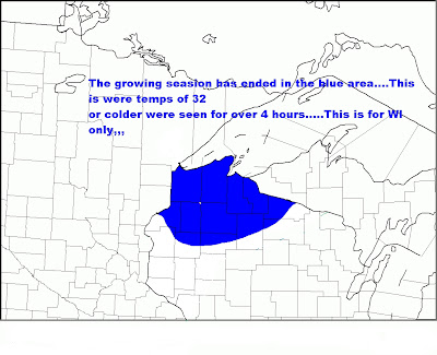
Parts of the area saw the growing season come to an end...Seems like any areas in Northern Barron County and Rusk County....North of a Cumberland to Rice Lake to Ladysmith line....South of this line there was patchy frost...Not a killing frost...
 
Killing frost last night….Areas that see the killing frost are as follows….

Official temp at the Rice Lake airport was 32 degrees it held at 32 degrees for 6 hours.

Over in Rusk County temps at the Rusk County airport was 32 degrees it held there for 3 hours…

The growing season has ended for Northern Barron County, Northern Rusk County…..
 
Cumberland’s airport saw 34 degrees for 3 hours…..(Not a killing frost)

Temps in Polk County stayed above freezing.(no killing frost)

Here is the map to show you were the growing season has ended this morning…
 

Thursday, September 13, 2012

Fall color update 2


Despite all the negativity I have read about the hot summer affecting the fall colors…Well let’s just say this pictures don’t lie, and we aren’t even close to peak yet….Though the change over started about two weeks earlier..Were the colors are at now…This should be like toward the end of this month…..I think this year so far has been better than last year…..See for yourself! Forecast found below....


Forecast for Western/Northwestern WI.


Areas of frost possible for tonight…A little warm up for the weekend….Cooling back down next week with off and on showers/storms…..Let us try to work all this out…..

***CURRENT CONDITIONS***

Looking at the current vis satellite we see clearing skies across the FA, however we see more high clouds forming over in MN….

As of 11 am we see SFC OBS reporting fair/high clouds….Temps are in the lower 60s with winds calm to NW around 6 MPH….

***SHORT/MIDDLE TERM FORECAST DISCUSSION***

Today we see yesterday’s system well to our Southeast over Southern and Eastern WI….This did bring some much welcomed rain to the FA… Today we still could see a few ISO showers pop up from time to time….Should be far in between….Looks like the cooler pool of cold air aloft will set up just North of my FA today…..Tonight’s frost problem will be factored by a few things….1. if we can clear the skies off. 2. If we can get winds to stay light to calm all night. 3. If dewpoints remain low…..The only concern I have is models are showing partly cloudy skies for tonight, this will keep the good radiation cooling effect somewhat at bay…Do feel that areas of frost will be possible North of a HWY 48 line in Barron County, Polk County, and North of a HWY 8 line in Rusk County…..South of said lines… Thinking is Patchy frost is going to be less of a problem ATTM…Right now it appears this will not be a hard frost or a killing frost….Will watch trends throughout the day…Short term forecast will cover this if needed…..

Still will be cool for Friday, however WAA will slowly start to kick in…So we should see temps a few degrees warmer than today…Lows Friday night should hang around the upper 30s to lower 40s…So frost threat for Friday night looks null….

SFC winds from the Southwest/South will usher in warmer air for weekend…Highs on Saturday should top off in the middle 70s in my Central and Northern areas while upper 70s in my Southern areas….Sunday upper 70s over my Northern and Central areas, while my Southern areas could see temps either side of the 80 degree mark…..Will be a good weekend to get some yard work done, and or check out the fall colors…..Sunday night a cold front will push into the area…Looks like this will be the same setup we just got done going through…Showers and thunderstorms will be found just behind the cold front….Will carry the showers and thunderstorms to around the 10 – 11 AM hour of Monday….Temps will fall into the lower 60s for Monday….Monday night still may see a few showers around, However looks to be cloudy this will keep temps from hitting rock bottom…The same will hold for Tuesday and Tuesday night…If the clouds clear out on either of those nights we could be dealing with a hard frost/killing frost mainly in my Central and Northern areas….We will have to see how this plays out as we get closer to that time frame….

So to sun up the short/middle term…..Cold tonight cool tomorrow/ warming for the weekend/ than cold for the rest of the period….

***YOUR SHORT/MIDDLE TERM FORECAST***

TODAY. A few iso showers possible with partly cloudy skies. Highs 64 to 68…

TONIGHT. Partly cloudy lows ranging from the middle 30s North to around 40 South..Areas of frost possible North…Some patchy frost possible Central….

FRIDAY.Sunny highs around 70

FRIDAY NIGHT. Clear lows around 40.

Saturday through Sunday.Sunny highs in the 70s lows in the lower 50s….Chance of showers maybe a thunderstorm Sunday night.

Monday through Wednesday.Off and on clouds and Iso showers….Cold temps I the middle 50s to around 60…Lows in the upper 30s to around 40…See above for what could happen if we get clear skies at night…

***LONG TERM FORECAST DISCUSSION (09/20 -09/29)***

This period starts off on the cold side then it warms up some by Tuesday the 25th ….

What is really interesting is the GFS model is showing a chance of rain/snow showers  from the 20th through the 23rd… The 22 the GFS model shows a clipper like system dropping into the area with snow showers…. I would not be shocked to see this, but am having a hard time buying into this that far out….Something we will have to watch though….Temps from the 20th through the 23/24 will be cold 40s for highs lows in the 20s to 30.

After that we see a slight warming trend for the rest of the time frame…A chance of showers for 25 and the 28th with dry times in between….Highs should get back up to around normal lower to middle 60s with lows either side of 40…..

So to recap…

We start this time frame on the cold side and could even see our first snow/snowflakes of the fall…..Then we slowly warm backup to neat normal….


Sunday, September 9, 2012

Forecast for Western/Northwestern WI


The upcoming work week will see temps start above normal, then go below normal after Tuesday. We could also get into the same weather pattern that has affected us yesterday and the Friday with insatiability showers and maybe a thunderstorm here and there….Big story comes the week of the 17th a weather pattern change is in the works for the FA….Big cool down and yes it looks like we could see our first frost or we may come close to ending the growing season….

***CURRENT CONDITIONS***

Across the area at 10:00 AM we see skies ranging from sunny to partly cloudy….Temps upper 50s to lower 60s. Winds are light out of the North from 3 to 7 MPH…..

*** SHORT & MIDDLE TERM FORECAST DISCUSSION***

Two main concerns in the short/middle term forecast… 1 how windy will it get for Monday and Tuesday…. 2 How high to go with temps on Monday and Tuesday….

Today we should see more sun than clouds, still somewhat a cool pool of air sitting overhead most of that has shifted to our East…So I would except to see clouds and showers in far Eastern WI this afternoon. High pressure is forecasted to build into the area…This will allow for a very nice day across the Northwoods.Highs in the lower 70s throughout much of the area, my far Southern areas could reach for the middle 70s. Winds will not be strong today as they were yesterday afternoon. Tonight high pressure overhead will allow for light winds, temps should fall easily into the lower to middle 40s….Only reason why I’m not going with the upper 30s is our winds will become South/Southeast this will allow for WAA to kick in tonight keeping the temps in check. On Monday the high slips to our East/Southeast. A low pressure out west the pressure gradient between the two will allow for our winds to pick up…Thinking is as of right now the strongest winds will be found over in the Southwestern part of MN…..Nevertheless we should see winds in our area from 15 to 20 MPH with gust close to 30 MPH…Models still show rather breezy conditions for Tuesday …II didn’t buy into the 30 MPH winds, how can buy into 10 to 20 MPH with gusts close to 25 MPH…..This will allow for very warm conditions to overtake the area Monday and Tuesday….Highs on Monday close to 80…. Highs on Tuesday middle 80s to upper 80s will be possible…..If we would have more a of Southwest wind component we could have seen temps pushing close to 90….However that is not the case….

A dry cold front pushes through the area on Tuesday night…This gets hung up in the Southern areas…With the front being this close and a pool of cool temps above sure can’t rule out some showers and maybe a storm or two from Wednesday into Friday….Temps will have no were to go but down…Highs will fall into the upper 60s to close to 70s….May see a day or two with temps in the middle 60s..

***LONG TERM FORECAST DISCUSSION***

Next weekend  we start with highs in the lower 70s our highs on Sunday the 16th look to be around the upper 60s to lower 70s. Highs on Monday only in the upper 50s to lower 60s.Dito for Tuesday. A little warmer on Wednesday the 19th  with highs forecasted to be in the middle to upper 60s.Temps cool back off on Thursday, back into the upper 50s to lower 60s. highs on Friday close to 60s with middle 60s far South. Same hold true for Saturday the 22th. And Sunday the 23rd   Monday the 24 highs upper 40s to lower 50s….

Lows through this time frame will be in the 40s with some nights dropping well into the 30s…Looks like we will see out first frost of the fall, may even end our growing season over my Central and Northern parts of the FA…..Looks like this period will be wet…Will be chances of showers along with some thunderstorms…..However the main story will be the temps….Looking at the CPC forecast…..Their 6 to 10 day outlook shows us below normal in temps.Their 8 to 14 day outlook keep us below normal…So that matches up with the long term forecasting models….

Thursday, September 6, 2012

2012 fall colors 1

Once a week I will bring you pictures to show how fast the fall colors are changing...With nights getting longer, along with forecasted temps to be  warm during the day, with cool nights, we shall see the colors really start to take off....So here is week 1.Side note there are more colors now than there was just a week ago.


Wednesday, September 5, 2012

09/04/2012 severe thunderstorms


Yesterday saw  an explosive thunderstorms over Barron County, The storms also started to form South of Barron County, by time they reached the Eastern part of Barron County they joined forces with the storms to the South to form a solid line…..

I was able to stay out of the main hail core, but still got hailed on….The pictures below is the size of the hail that failed in Rice Lake….Some hail up to 1.50 to near 2.00 inches in dim. Fell across the Southeastern part of Barron County….Other parts of the FA also saw severe thunderstorm……My far Western areas didn’t see a rain drop…..
Here are some pictures.


Below is the storm reports from the NWS.
..TIME...   ...EVENT...      ...CITY LOCATION...     ...LAT.LON...
..DATE...   ....MAG....      ..COUNTY LOCATION..ST.. ...SOURCE....
            ..REMARKS..

0350 PM     HAIL             HOLCOMBE                45.22N 91.12W
09/04/2012  M0.75 INCH       CHIPPEWA           WI   TRAINED SPOTTER

0356 PM     HAIL             4 S CHETEK              45.26N 91.65W
09/04/2012  M1.00 INCH       BARRON             WI   TRAINED SPOTTER

0402 PM     HAIL             CHETEK                  45.32N 91.65W
09/04/2012  M2.00 INCH       BARRON             WI   TRAINED SPOTTER

            NUMEROUS LARGE HAILSTONES NOTED BETWEEN ONE INCH AND TWO
            INCHES IN DIAMETER. TIME ESTIMATED FROM RADAR.

0403 PM     HAIL             CHETEK                  45.32N 91.65W
09/04/2012  M0.88 INCH       BARRON             WI   TRAINED SPOTTER

0409 PM     HAIL             10 E RICE LAKE          45.50N 91.53W
09/04/2012  M0.75 INCH       RUSK               WI   TRAINED SPOTTER

            HAIL HAS FALLEN FOR SEVERAL MINUTES WITH LARGEST DIAMETER
            OF DIME SIZE.

0410 PM     HAIL             CHETEK                  45.32N 91.65W
09/04/2012  M0.88 INCH       BARRON             WI   TRAINED SPOTTER

            NUMEROUS PENNY TO NICKEL SIZE DIAMETER HAIL.

0412 PM     HAIL             2 SE CHETEK             45.30N 91.62W
09/04/2012  M1.50 INCH       BARRON             WI   COCORAHS

            SOME MINOR LEAF DAMAGE NOTED.

0445 PM     HAIL             3 E NEW AUBURN          45.20N 91.50W
09/04/2012  M0.50 INCH       CHIPPEWA           WI   PUBLIC

            PUBLIC MEASURED 5/8 INCH HAIL EAST OF NEW AUBURN...

0523 PM     HAIL             2 N BRACKETT            44.73N 91.35W
09/04/2012  M0.75 INCH       EAU CLAIRE         WI   TRAINED SPOTTER

0530 PM     TSTM WND DMG     STANLEY                 44.96N 90.94W
09/04/2012                   CHIPPEWA           WI   TRAINED SPOTTER

            TREE ESTIMATED AT 70 FEET TALL AND 2.5 FEET IN DIAMETER
            TOPPLED.

0546 PM     HAIL             3 S FALL CREEK          44.72N 91.27W
09/04/2012  M2.00 INCH       EAU CLAIRE         WI   TRAINED SPOTTER

Tuesday, September 4, 2012

Looking back at August 2012


Looking back at August 2012…

One thing about last month was we saw the heat and humidity break…In fact there was two weeks we saw temps drop below normal for a change……That didn’t last long as we saw the heat and humidity make a strong come back… We did tie a record high of 91 on August 30th..That record was set back in 1974…

We saw 10 thunderstorm days.

We had 2 severe thunderstorm days….

Time to break this down….

Non Severe thunderstorm days are as follows.

1, 2, 9,13, 19, 22, 23, 28.

Total thunderstorm days was 10. This is up by one from last year.

Severe thunderstorm days are as follows.

Late night of the 3rd, early morning hours of the 4th.

Watches/warnings.

There was no tornado watches.

The was 1 severe thunderstorm watch that ran from 10:57 PM of the 3rd to 4 AM  on the 4th.

There was tornado warnings issued.

There was 1 severe thunderstorm warning issued. The warning was issued at 11:39 PM on the 3rd and ran through 12:45 AM on the 4th.

Looking at the month of September.

So what can we except this month….

The avg high temps start off at 75 on the 1st, and cool down to 63 by the 30th.

The avg low starts off 54 on the 1st, and cools down to 41 by the 30th.

Last year we saw a freeze warning issued for the area on the 14 and 15. In fact we had lows middle 20s which brought the end of the growing seasion.

So for those who hate the humid and hot weather…..This month is a month of change…..

Looking at some long range forecasting models…After this heat wave which is forecasted to break tomorrow….Looks like we will see a cool down with temps at or slightly below normal for the rest of the month.