Wednesday, December 31, 2008

The NWS has fixed my report...

There I see my report has been fixed....Talked to my Brother this morning,he lives like 8 miles Northwest of Cumberland he picked up darn near 14.75 inches of snow....So today I will be out in the Northern areas of Barron County checking snow amounts just to see how much of the area was in the 14 plus inch range....Also will see where the foot mark ends through the Central part of the County...Ok so I'm really bored today...

Forecast..Off and on snow, up and down temps

Forecast problems through the rest of the week and upcoming weekend,along with the middle, and longer term forecast...Temps along with off and on snow chances...

Current Conditions...

Temps over the fresh snow pack really took a dive last night....Most areas reporting middle teens below zero,Here at the office 19 below...Did come up a little...Other areas that did not pick up as much snow are reporting temps in the single digits below...Skies are clear through the area...Winds for the most part are calm to light...


SFC ANALYSIS....

The system that brought heavy snows to parts of the FA is now well of to our East...Meanwhile this morning we find a 1039 MB high pressure centered over Southern SD...Our next system of interests now coming on shore in British Columbia with a frontal system pushing on shore in WA,and OR......A break Friday..Our next area of interest coming on shore around Northern WA.....This will bring another shot of snow to the area starting Friday late night and lasting through late Sunday...

Today....

Ridge of high pressure keeps building into the area...This shall ensure us mostly sunny skies and lighter winds...Temps will be hard pressed to get through the single digits through out much of the FA..May go above 10 or so in my Southern areas of WI..South of a line from ST.Croix to a Taylor Counties....All in All a great day to get out and enjoy the snow...

Tonight through Thursday night...

High pressure slips away and wind are forecasted to become Southerly..WAA kicks in so temps won't get out of hand like Tuesday night...SFC low pressure will work its way closer to the area...This low is forecasted to hang the MN,Canada boarder..By 06z Thursday the low should be just North of ND by 12z low will be pushing just North of MN this will drag a frontal boundary into MN and through WI by 00z Friday...Snow is forecasted to break out ahead and long the cold front with some wrap around snow behind the front....Best forcing and lift will remain well North of My FA....Parts of Northern WI could pick up 1 to maybe as much as 3 inches of snow,While the rest of the FA picks up from an 1/2 to as much as 2 inches of snow...Temps should be in the 20s for the most part,while some lower 30s possible in my Southern areas..Lows tonight should be either side of zero Central and Northern areas...While in my Southern areas temps in the single digits seem to be the way to run.

Friday...

A break in the action once again..Temps Friday will be a few degrees cooler that Thursday as more Arctic air flows on behind the departing system...Lower to middle teens for highs while lows dip to lower to middle single digits....

Friday night through Sunday....

More snow on it's way through this time frame....By Friday 12z we find a 994 MB low pressure over Northern ID..This low is forecasted to move East ...Looks like a inverted trof is going to set up over the FA...GFS model is painting around .25 QPF for the area..If this plays out we good be dealing with another winter storm,like the one we just got dealing with for the weekend...We will watch it as models aren't seeing eye to eye on the finer details...This will be worked out over the next few days...

Longer term..Jan 6 th through Jan 16 th...

This time frame looks to be off and on shots of Arctic air....Bt the end of the period models showing the mother load of Arctic air ready to dump in the FA if this does pan out we could be dealing with the coldest air of this winter by Jan 16 th..This all remains to been seen this far out...Will still see off and on snow chances as systems work their way down through the pesky Northwest flow that has plagued the area most of this winter thus far....

Tuesday, December 30, 2008

Winter storm pictures


Well I'm not sure of my ending snowfall amount...I will find out in the morning..Thinking I'm going to push the 14 inch mark....Here are some pictures taken during the storm...

Forecast right on target

That was the fastest I have seen my forecast verfiy...That I do like...Now I can rest,without worry if this was going to bust or not....

Still snowing

@ 7:30 Am up to 5.5 inches of snow...Still coming down at a good clip..Will have more pictures when all is said and done...Been a very busy morning...On the phone with NWS and others....

Heavy snow


Heavy snow falling...3.5 inches since 4 AM...Half dollar snow flakes....

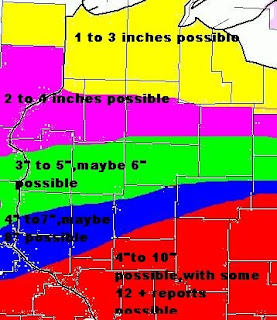
Forecasted snow amounts....


Color code for the map....
Purple = 1 to 3 inches possible..May see some 4 Inch reports...

Yellow = 2 to 4 inches possible...Could see a few 6 inch reports...

Light Blue = 3 to 7 inches possible...May be some 8 inch reports...

Light Green = 4 to 8 inches possible....May be a few 10 inch reports.

Red = 5 to 10 inches possible...Would not be shocked to see some 12 inch reports..
The reason why I added the may could see higher reports...Is the fact that,some areas could see more snow,the main reason is a lot of reports are estimated or not measured correctly...I have seen this a few times this year,and just happen to be in some areas where the reports were much higher than what they should have been...I'm sure I will be called out more than once today to verify some over or under estimated reports like the past few snowfalls...Plus with the winds forecasted that will only make getting snowfalls that much harder...

Forecast..Map to follow soon...

Forecast problems....Today heavy snow...Arctic air for tonight through Wednesday night...More snow for New Years Day,More cold air and more snow for Saturday...Will have more discussion on the later systems in tomorrows forecast.....

Discussion....

SFC low pressure over SD is forecasted to race into and through Central/Southern IA today..Low is forecasted to be near Chicago land by 2100 UTC...Models still showing the best lift/forcing over said areas in yesterday's forecast(read below for areas to pick up the most snowfall)...However snowfall amounts have changed...Will have a map out for them detail....Looks like Central and Northern Counties of Barron,Polk,and Rusk Counties could pick up 8 to 10 inches of snow today...Would not be shocked to see some 12 inch reports...With 4 to 8 Inches for Central and Southern areas of said Counties..In this area I would not be shocked to see a few 10 inch reports....Further South 3 to 6 inches of snow looks to be on the docket....Winds will be on the increase for today as pressure gradients increase between the low and high pressure of to our Northwest...This will add more headaches for the plow crews today,as blowing and drifting snow will become a problem....
See map for the details on snowfall amount....
Tonight the low pressure pulls far enough way,takes the snow and clouds with it...Temps will take a hit tonight...Should easily drop close to -10 if clouds clear out soon enough....Wednesday a break in the action,however it shall be a cold day with temps struggling to get out of the single digits....Wednesday night clouds increase we should see temps slowly raise over night as WAA slowly kick in...Thursday another system is forecasted to move into and through the area...Thinking at this point in time the accumulating snows will hang to the Northern parts of my FA...More on this tomorrow....Need to put more time on this winter storm effecting the area today....
Forecast issued @ 5:08 AM

Monday, December 29, 2008

Not much change needed to forecast/did fine tune snowfall amounts using a point to point system.

Side note...

I see the NWS is starting to buy into this forecast...Still I think they have not picked up on the finer details for the most part,they are slowly getting there though...Just shows you not all forecasters will agree all the time....

Forecast is still on track...Everything is looking good in the short term and middle term along with the long term...So no big headaches...Arctic air will become more established over the area..

Current Conditions....

Temps have warmed up nice over night...Temps went from the teens to the twenties..Winds have begain to pick up...This will be the trend for today...Radar still showing some light snow/flurries over Rusk County..The area should clear within the next hour...


SFC ANALYSIS....

Low pressure at the head of Lake Superior this morning,,,Trailing cold front through Central MN ,meanwhile we see a warm front slicing through WI..1026 MB high pressure over Saskatchewan Canada...Our next system is sitting over the OR and WA...

Today through Tonight...

Low pressure over LK Superior will keep treaking Eastwards this will drag a cold front through the area before 18z today,this will also bring to an end to the snow falling across Northern WI....1026 High pressure is forecasted to build into the area through the day and tonight..Pressure gradients will increase between the low to our East and high pressure building in from the Northwest..This will lead to winds gusting up to 30 MPH....Temps today for the most part have reached there highs...We should see them falling after the cold front pushes through....Will increase clouds for tonight might see some light snow start to break out late tonight as the atmosphere become saturated at a rather fast pace......

Tuesday through Wednesday night....

Low pressure is forecasted to be in MT around 00z Tuesday this low is than forecasted to track into Southeast SD by 12z Tuesday,By 00z Wednesday the low should be over Northeast IL....This track as been forecasted over the last few days...Frontogenesis is forecasted to move into the FA...System does have enough moisture to work with and models keep pointing at the best forcing over Northern,and Central areas of the following Counties Barron,Polk,into Rusk Counties...This would be the likely areas to pick up 3 to 6 inches of snow, with some areas in Barron and Rusk Counties could pick up 6 plus inches of snow...Points to the North of said Counties can except anywhere from 2 to 4 inches of snow.....Meanwhile points to the South of Central Barron,Polk,and Rusk Counties should see 2 to 4 inches also....May be a few 5 inch reports closer to the Central part of said Counties...Lets break this down into a line...Points North of a Balsam Lake to Cameron to Weyerhaeuser line 3 to 6 inches...Points Just North of Cumberland to Rice Lake and Bruce Line could see 6 plus inches of snow...Points South of a Taylors Falls, Turtle Lake and Sheldon should see 2 to 4 inches of snow......
Snow should fall mainly during the late morning and through the afternoon hours....Tuesday night system pulls far enough away we could see skies slowly clear...This will set the stage for temps to fall to below zero readings...Wednesday we get a break in the snowfall dept..Though temp will struggle to get out of the single digits...Temps will fall below zero once again for Wednesday night....

New Years Day through Saturday....

We find yet another storm system that has it's eye's set on the FA to ring in the New Year....Oh we aren't done yet, Saturday yet another system is in the decks..Each passing system will sever to draw more colder air into the FA Temps in the teens to lower twenties with lows either side of zero..More on these system through out tomorrow......

Sunday, December 28, 2008

Forecast/not seeing eye to with the NWS on this one!

Forecast headaches for short term and middle term...Arctic air.....Snow chances...Winds....

Current Conditions...

SCF OBS showing that temps really took a hit last night...At this hour we find temps well below zero through out much of our MN FA..Over in WI temps hanging onto the teens above...Still some light snow/flurries at this hour but mainly clear skies our found over are Western into our Central FA of MN..Over in WI skies range from PC to MC with some light snow/flurries being reported at this hour...

SFC ANALYSIS...

Strong low pressure is centered over far Northwestern MI this morning,meanwhile 1007 MB high pressure over Southern Manitoba/Ontario Canada..We also see our next system over Western Alberta Canada This is showing up rather well on the WV...

Today through Monday..

Storm system that has brought all the severe thunderstorm activity to our Southern and Central States is forecasted to keep pulling Northeast into Canada..Any light snow/flurries that are still around shall be ending rather soon...Weak ridge of high pressure builds into the area...This should push any remaining snow/clouds out of the area,setting us up for a rather peaceful day...We will be watching a 1004 MB low pressure dropping into MT today...This low is forecasted to move into far Eastern ND by 06z Monday than to Lake Superior by 12z Monday....This will be a shot at 1 to 3 inches of snow across our Northern areas of MN tonight into early Monday morning..Winds will also become a problem as pressure gradients increase between the 1004 MB low and a 1024 MB high pressure to our Northwest...Would not be surprised to see winds gust up to and above 30 MPH at times...Mainly over our Central and Northern areas of MN and Northern WI....20 to 25 MPH wind gusts possible over the rest of the FA for tonight and Monday....Monday we get a break in the snow for the most part...

Monday night through Tuesday...

Things get interesting...Looks like our Central and Southern areas of the FA could be dealt a card for accumulating snows...Still a little early to pin down the amounts,and locations,However the way it stands right now looks like points South of a line from Brainerd MN to Hayward WI could be in the range of 6 plus inches of snow...Taking a look at the HPC snow forecast they agree..We will see what happens....

Wednesday through Thursday...

Another break in the action for Wednesday,We are still watching a system that could bring more accumulating snow to parts of the FA....
Arctic air try's to take hold of the FA through out this whole forecast cycle...A roller coaster ride in the temp dept is forecasted...Still nothing like the last cold snap we had...So temps should avg to right around either side of the norms.Daytime highs in the teens to 20s while night time lows below zero to the upper single digits for the most part...

Saturday, December 27, 2008

Updated forecast@ 3 PM posted @ 8:20 PM do to internet problems

Updated forecast...
Showers and thunderstorms,along with a line of severe thunderstorm to the South/Southeast has robbed most of the moisture that was excepted to work North tonight...
This will limit snowfall amounts...Still could see and inch or 2.for Central and Eastern Barron County and points to the East and Northeast..Might see an 3 inch report over in Rusk County......Zones will be updated soon.....
Previous forecast discussion below....

Forecast/MY AFD from the site I forecast for!

Forecast problems will focus on tonight's snowfall over our far Eastern parts of our WI Counties,Mainly Barron,Price,Rusk,and Sawyer..Fog this morning with mixed percip.....Temps are another concern for the long term...

Current Conditions....

Temps starting off rather warm this morning...Upper 20s to lower to middle 30s..Fog still remains a problem through out the FA..
Winds are starting to back to the Southwest to Northwest except that trend through the morning hours..Fog slowly to also lift this morning..Radar is showing some light returns over Northwestern part of St. Louis County MN...SFC reports showing some light freezing drizzle and light snow...This is moving off to the Northeast and should be in Canada in the next couple of hours....

SFC Analysis....

Cold front is now moving through parts of our WI Counties..This will also clear out of our Northeastern Counties of MN...Low pressure over North Central MN with cold front reaching back to a 1000 MB low pressure over OK...This will be the topic of most of this discussion....

Today through tonight....

First off we need to address this morning's fog....Fog has been quite dense through the over night hours..Fog should be on the way out this morning as winds pick up speed and bring in a little drier air..Cold front that is currently over the area should be over Eastern WI by 12z today...Low pressure over OK is forecasted by the models to move Northeast rather fast..By 18z today the low should be over Northern MO..By 00z Sunday said low should be over Southern WI between a Madison and Janesville area..By 06z Sunday said low should have pushed into Western MI...With the track of the low more to the West and North than forecasted yesterday this will push the snow line more North and West than thought..Meanwhile as the low pressure moves Northeast it is forecasted to deepen to around 996 MBS as it pushes into Southern WI....As it reaches Western MI the low is forecasted to deepen to around 985 MBS...We may have to increase wind speeds for later tonight into Sunday...Will hold off on that for now, and see what some more model runs show....As of right now it would appear that our Eastern Counties of our WI FA should see from 2 to 4 inches of snow tonight there will be a fast cut off line...Central and Eastern Barron County and points East and Northeast could pick up 2 to 4 inches while our Western part of Barron County and points West and Northwest,and our neighbor Polk County may not see anything more than 1 inch,maybe two inches if they are lucky....If the track goes a tad more West/North said areas could pick up 2 to 4 inches,while Central and Eastern Barron County and points East and Northeast could pick up 3 to 5 inches...Will keep an eye on this through out the day...As time is still on our side to decide how to handle this....

Monday through Tuesday....

A weak like clipper system is forecasted to move into North Central MN by 12 z Monday...Will be forced to keep snow wording in the forecast,Mainly our Northern areas......

Longer term....

We are watching a system that could be effecting the area late in the up coming short work week...Right now my confidence level is really low with this system so will hold off on details for now....This does system will be needed to watch close though.

Friday, December 26, 2008

Forecast/temp conversion lesion

No major weather headaches in the short and medium periods...As a weather pattern change is in the works,after seeing very cold air and snow over the last 3 to 4 weeks...
Analysis...
Strong Southerly winds have brought much warmer air into the FA over the night time hours...So light snow moved through last evening out ahead of the push of warm air....Not much snow to talk about with that...
Today through Sunday....(short term)
Really not to much to talk about,Southerly winds will keep bring in warm air.Temps today could reach into the lower 30s...I think middle 30s are out of the question with the deep snow pack,however some of our warmer areas could hit the middle 30s ...Low pressure over SD is forecasted to move to push into North Central MN by 06z Saturday...This will keep the chance of light mixed percip around the area through Saturday night...As this low will drag a cold front through the area,however won't be like the last cold fronts as the air behind this one is from the Pacific..Saturday night temps to take a dive into the single digits above 0...Sunday I have knocked off a few degrees from model guidance so middle to upper 20s should play out rather well..
Monday through Wednesday...(middle term)
For the most part this period looks to be rather quite,however one little system may brush the FA with some light snow around the Monday/Tuesday time frame...ATTM does not look like nothing much to talk about with this system....Temps will remain on either side of the norms...Thanks to the deep snow pack temps won't get out of hand going to way above norms...Tuesday night into Wednesday night does look cooler as a cold front pushes through....Some hints that a piece of Arctic air may try to break off and head South over the FA.....
Longer term..
We will be watching a storm system for the New Years Holiday,Have been seeing with each model run the system is more South of the FA...However we have seen this many times this far out in the forecast cycle...Also looks like the first part to middle of Jan we will be tossed right back into the Arctic air....Still to early to tell how cold it will be...Long range models showing temps of - 8 c to -20 C common through the period..With temps warning to around -8c to -4c by the end of the period..Temps in c would translate to.... -4c = 24.8f -8c = 17.6 f -20c = -4 f......
Lets talk about how to convert temps...
Let convert temps from Celsius to Fahrenheit...
It's a rather easy process...All you need to do is take the Celsius reading multiply by 9 then divide by,then add 32...This will give you your reading in Fahrenheit...Lets try it....
Let say the Celsius temp is - 32....ok so we times that by 9 which = -288 divide that by 5 that =
-57.6 + 32 = -25.6....So remember this equation....(°C x 9/5) + 32 = °F...
Now if we wanted to convert Fahrenheit to Celsius we would use the following equation...
(°F -32) x 5/9 = °C....SO there you have it a fast learning lesion on temperature conversion.. To really understand the computer models one has to know how to convert from c to f...If not one will miss the finer details which will cause the forecast to bust...

Monday, December 22, 2008

More snow on the way...

Forecast headaches...Snow,and cold...Same old story
Current Conditions....
Temps took a hit again last night..At this hour temps are in the teens to twenties below zero.SFC OBS showing partly cloudy to clear skies through Northwestern WI,along with Eastern MN.

SFC Analysis...
This morning we find a ride of high pressure over the area.This has allowed skies to clear out over night and temps dived to the teens and twenties below....Our next storm system is over the ID at this hour..

Today....
Arctic air ridge of high pressure remains in control of the weather...The SFC high it's self should be around the Northeast OK area pressure readings around this high are coming in at 1038 MBS..Meanwhile up in our neck of the woods we see pressure readings around 1028 MBS...Winds today shouldn't be a big factor around 5 to 10 MPH,however with temps only forecasted to be in the lower to middle single digits wind-chills will still drop to around -20 to -30 at times today...

Tonight through Tuesday...
We see the storm system over ID move into WY,another low pressure gets going over Eastern CO...Trof will extend North of the WY low into SD,and ND by 00z Tuesday.By 06z Tuesday the we see a 998 MB low pressures over far Southern SD/far Northern NE...Trof reaching North from said low into the Central parts of the SD,and ND...Low over CO deepens to around 996 MBS...By Tuesday 12z low pressure over NE is forecasted to scoot Northeast into SD,said low should weaken to around 1001 MBS..Trof will reach from low into Southern MN, and WI....With Southerly winds out ahead of the low we should see some over running snows...So using different methods I can up with around an inch or two of snow for later tonight,using the same methods looks like 2 to 5 inches for Tuesday morning into the early afternoon...Total storm accumulations could range from 4 to 6 inches... Temps will remain cold through Wednesday....

Wednesday...
Will have to keep the snow chances going as models still have the low close enough to the area some models are trying to strengthen the low if this does indeed happen parts of my FA could see more snowfall,around another 1 or 2...This remains to be seen right now....

Wednesday night through Christmas day...
A 1016 MB high pressure will take control of our weather...This will allow temps to drop to below 0 for over night lows,However Christmas day is looking really nice with highs reaching into the upper teens...

Friday through Saturday...
Looks like another system could effect the area.The way it looks right now models are all over with this system so my confidence is really low with this forecast period...Temps do look to warm into the 20s on Friday only to drop back off once again ....

Sunday, December 21, 2008

Orion pictures


I had to get out and take some pictures of Orion...I will be heading back out soon...Playing with the settings to see what will work best...Click on the picture to see the larger size..

Some pictures


Got 4 inches of snow last night...One thing it's cold outside -12° right now wind-chills -39°


Forecast

Winter storm coming to an end across much of the FA this morning...We still will be dealing with off and on areas of light snow through out the day...LES machine has kicked in so will have to run with another 3 to 5 inches of snow for the WI snow belt areas...Other than that temps will be a problem,along with wind-chills.Then yet another system to spread more snow across much of the FA....I did trim temps down a degree or two across the FA...
Current Conditions...
Radar still showing snow through out much of Northeastern MN,as well as Northern WI...LES snow band also showing up rather well this morning...Temps took a hit last night as SFC OBS showing most stations well below 0 at this hour..Winds remain rather gusty with some station across MN reporting winds gusting up to 20 to 25 MPH leading to wind-chills values from 30 to 40 below..Winds a tad lighter in WI ranging from 9 to 18 with gusts up to gusts up to 20 MPH...Here at the office winds are 9 MPH with gusts up to 17 MPH wind-chill here is at 30 below...
SFC Analysis....
Low pressure that brought accumulating snows across the FA area yesterday and last night in now over far Eastern WI...Strong Arctic high pressure over MT ...Pressure gradients between this two system will keep the winds up today....
Today....
Said low above is forecasted to move into Eastern MI by 12Z Sunday..This low is going to drop a trof into the far Northeastern tip of MN and then through our WI FA...This trof will keep the chances for light snow going...Little in the way of accumulation is forecasted...Maybe close to an inch most areas...Far Northeastern MN could pick up 1 to 2 inches of snow...In our snow belts of WI LES might become a problem,here we are forecasting another 3 to 5 inches of snow through out the day...Meanwhile Strong Arctic high pressure over MT...This thing has a MB reading of 1044...Strong high to our West and Low to our East pressure gradients stay up,so a windy day on tap...This will lead to blowing and drifting snow..Also one might run into areas with close to white out conditions,in the rural areas..
Tonight....
Arctic high pressure slowly starts to build in...I do have the forecast with mostly cloudy wording,however I would not be shocked to see some areas clear out sometime tonight...Winds will slack off,however with temps dropping well into the teens below and some twenties below wind-chill values will still be a factor...
Monday...
Arctic high pressure in full control of our weather will insure us a mostly sunny day..Temps will remain in the single digits on either side of 0...I kept them above 0 in the forecast...A much needed break in the snows...That won't last very long....
Monday Night through Tuesday....
Another storm system has it eyes set on the FA...Looking at the WV this morning we find the system off the coast of British Columbia Canada...This system is forecasted to move into ID by 06z Monday..A trof will move into the area Monday night through Tuesday this will once again lead to some accumulating snows...Right now looks like a range of 2 to 5 inches will be possible across the FA...
Temps will be up and down through the Forecast period...Slightly warmer air for Christmas day with another shot at some snow...Models having a hard time with that possible system....

Saturday, December 20, 2008

Heavy snow falling/pictures


Heavy snow is falling...We got 3 inches at the weather center so far...More to come....Here are some pictures..

My HWD outlook...

*** WINTER STORM ***
This HWD is for the entire forecast area....
The NWS has issued a Winter Storm Warning for the whole FA from now through 6 PM CST Sunday night...
Today through Sunday night....
Low pressure and a couple of trof will effect the area through this time frame....This will ensure the FA a prolonged snow event...Snow this morning will become more widespread and heavier as we walk through the day...Daytime snow accumulations shall range from 3 to 8 inches...Tonight snow will keep plowing through the area with another 1 to 8 inches forecasted....Total storm accumulations shall range from 4 to 15 inches...See local forecast for more detailed amounts in you area...
Winds will also become a problem as we head into tonight and on Sunday....Winds could gust up to 20 to 25 MPH at times...This will cause blowing and drifting snow,making travel difficult to impossible across the area....Then to had more salt to the open wound...Temps are forecasted to fall through day on Sunday as more Arctic air moves South...This will cause dangerous wind-chill values...
If you must travel today through Sunday,make sure you carry a winter weather safety kit in your vehicle....If you become stranded stay with your vehicle,call for help if you have a cell phone...Make sure you let someone know when you point A and arrive at point B..Allow yourself extra time to reach point B....Best thing to do is get your running done early this morning...Or wait until Monday.....
Tuesday...
Another winter storm is possible...Will talk about that one in later HWDS....

My AFD

Did we go back in time ? Sure does seem that way,as we are talking about another major snowstorm...This discussion will focus on the winter storm to pound the FA...Very little in the way of long term discussion...
Current Conditions...
Temps are rather warm this morning,single digits to around the upper teens...Radar is showing a large areas of light snow through out the FA DBZ running around 10 to 20 or so right now..Snow is moving Northeast...Sorry not much more time left for the SFC OBS....
SFC analysis....
Models showing a trof over the Eastern Dakotas back down into Eastern NE..Mean while we see a low pressure over OK this low is forecasted to move almost do East to NC This low will not have a impact on our FA...We find a low pressure over Canada this is forecasted to dive in MN by 18z today then into Southeastern WI by 06z Sunday..The low is forecasted to move up towards Door County WI by 12 Sunday...Meanwhile as the low is pulling away we see another trof pushing South from said low.All these features combined will bring the FA an extended period of snow through the weekend..
Today through Tonight....
Snow will become widespread this morning and become heavier as we head through the day and into tonight as the low and first trof pushes into the area...
Sunday and Sunday night....
We still find the low over in WI around the Door County area with a trof being drove South into the area from said low...This will help keep snow chances alive....For the most part most of the FA will see less than inch maybe and inch of snow,However over the Northeast tip of MN they could pick up another 1 to 3 inches of snow...Wind will also increase in speed across the FA...This will lead to blowing and drifting snow...Blizzard conditions will also be possible through out the area....The Arctic gates open back up allowing for more cold air to pour into the FA....Temps should start to fall off in the afternoon...Wind-chills will also become a problem for Sunday into Sunday night..By Sunday night the light snow should becoming to an end across much of the area...Will keep it alive in the LES belts of WI and the Northeastern tip of MN....
Monday through Monday night....
LES will still be possible in our WI snow belts,otherwise look for a break in to snow today as we bask under mostly sunny skies...Temps will be a cold though...
Tuesday and Tuesday night....
Here we go again another winter storm on tap...This on looks to be a quick hitter through...Low pressure over CO is forecasted to move to move into Northeast IA/ Northwest IL/ Southern WI Tuesday..This track as of right snow should keep the heavy snows in our Central and Southern zones of MN and WI....We will fine tune this in Sunday's forecast...To much work going on with this weekend's winter storm...
HWD will be issued shortly...
Watches/Warnings....The NWS has issued a Winter Storm warning for the entire forecast area.of MN,and WI...

Friday, December 19, 2008

Here we go again.

***Major snow event***
Didn't we do this last weekend? Sure did..So lets keep on the same track...This will be about the same thing as last weekend...Low pressure will move South from Western MT down into OK then up in KT,then out to NC,per say that low will not effect us...However a low pressure/trof/upper level low is forecasted to move out of Southern ND into WI by 00z Sunday then into MI by 12 z Sunday....Moisture looks to be plentiful ...This system will also have the cold air to work with across all of the FA unlike last weekend's system....The way it looks as of right now a good 4 to 8 inches of snow on tap for the all of the FA...I would not be shocked to see some 10 to 12 inch reports through out the area...The NWS has issued a winter storm warning for all of the forecast area,except Barron,and Rusk Counties of WI...I feel that will be changing though.....Winds will become a problem as we slide through Saturday night and Sunday..This will lead to blowing and drifting snow....The Arctic gates open back up Saturday night and into Sunday night...This will to dangerous windchill values....
If you plan to travel this weekend...Make sure you let someone know when you leave point a and arrive at point b...If you become stranded stay with your vehicle and call for help if you have a cell phone,also make sure you have a winter safety kit in the vehicle..Stay tuned for more updates on this prolonged snowfall event...

Wednesday, December 17, 2008

Radars...

The reason I really don't like them "winter radar"...All it is, is a program some places use to color in where the radar thinks the snow mixed and rain is falling...This is mainly done with SFC temps computed into the program,so for the most part I find this to be off or wrong...It may be a guidance tool for those who really don't understand radar completely...Tho I would have to say this the WSI was for the most part right on with this past weekend event, as far as mixed precip goes...
Just like in the spring through fall...I don't like all them TVS,Hail,and Meso detectors...For the most part they are wrong,or never even show up....Here again it may be great for people who have little or no forecasting skills,however that could end up being a problem if one uses, that and tells everyone radar has a torn sig on it.That word spreads like wild fire and before you know the word is coming from the NWS and the truth of the matter is the word hasn't...SO one has to be able to really know how to read the radar to really know if there is a possible tornado there...Just cuz there is a torn sig there, in reality there may be no such tornado there...I have noticed many times when the radar had them little icons for tornados,and yet there was no warning issued....Just something to think about...I have years of research on radar under my belt ,and many hours put into learning how to read the radar..Unlike most new media and most people...Something I need to know when I'm out chasing storms...I read the radar wrong I could end up on the wrong storm,or worst yet I could end up dead...Just my take on radars...

Tuesday, December 16, 2008

The long awaited forecast

Sorry I forgot about some meetings I had to go to last night...
Anyway looks like this system moving in from Co today will remain South...However we still could see some snow...Thinking is around an inch or two through today and tonight...1 to three inches will be possible South of the interstate 94...
Next System come in from CO area on Thursday/Thrusday night...
CEP/ECMWF has a 999 MB low pressure over Eastern CO this low is forecasted to track to the Northeast over IA and MO then into the Ohio Valley...We could see another 1 to 2 inches,however most of the accumulating snows will be to the South...Over Southern WI...if this track holds...GFS has the same track and has been for the last few runs,but a little weaker...
NAM has the same track as GFS and about the same pressure.....So will run with the thinking a 1 to 2 inches of snow for now in the FA...
This weekend...We will be watching another system come out of the Southwest...This system as of right now looks to remain South of the FA,however if it does track more North would mean more snow,however this system is forecast to have a trof into the area which would help enhance snow...We will watch it as we get closer to that time frame....Cold temps will remain locked over the FA through the week....More Arctic air on it's way late weekend and into next week...

Monday, December 15, 2008

Snowfall amount from my office.

Total of 3.25 inches of snow accumulation last night.All in all I'm happy with the way the forecast turned out...Looks like we will doing this whole thing all over again....When ? you ask...Well I will let everyone know tonight after I get home from work....Could it be a another big storm like this? Again I will let everyone know tonight...One thing is for sure it will be cold today and tonight...This morning I have -7.4° Temps really won't be going up to far today...If we are lucky it may get a degree or tow above 0...Tonight heading down into the -20s......How long will this cold air be around you ask....That will also be tonight's topic of interest...

Sunday, December 14, 2008

Hazardous Weather Discussion(HWD)

***MAJOR WINTER STORM***
This HWD is for all of the FA....
Major winter storm slamming the FA today through tonight....
See AFD for the finer details...
Snow is forecasted to become heavy today and last through tonight....Total storm accumulations in MN will range from 8 to 18 inches of snow...Some areas could pick up close to if not over 2 feet of snow...Over in WI the total storm accumulations will range from 9 to 17 inches in the following Counties...Douglas,Bayfield, Ashland and Iron...5 to 9 inches of snow are forecasted for Burnett,Washburn,and Sawyer Counties....Meanwhile in Barron,Polk and Rusk Counties as of right now I'm forecasting 2 to 5 inches of snow along with some sleet accumulations...Thinking is the cold air will move in faster than thought yesterday at the SFC...Cold air aloft still hanging on so these Counties are at the border line...We will have to watch this area very close this morning....Would not be shocked if the NWS issues a winter weather Advisory or a winter storm warning for said Counties...
Temps will be falling through out the day as a very strong cold front pounds through the rest of the FA..Wind will also be on the increase...This will lead to blowing and drifting snow through out the FA...Travel will become nearly impossible if not impossible later today and through the night,as wind gusts up to 30 MPH most areas....A few areas could see winds gusts up to 40 MPH at time.This will cause near blizzard if not blizzard conditions through out the area......Winds combined with falling temps will lead to dangerous windchills......
If you must be on the roads today and tonight,make sure you have a winter safety kit along with you,let people know when you are leaving point a and when you arrive at b..If you become stuck remain with your car/truck,and call for help if you have a cell phone...This is a dangerous winter storm...Best thing to do is stay at home today and tonight...Listen to your local Media/the NWS/and us for more info on this major winter storm.
Winter storm warning now in effect for Burnett,Sawyer,and Washburn Counties of WI..The NWS has also Issued a winter weather Advisory for Barron,Polk,and Rusk Counties...The NWS is calling for 1 to 4 inches of snow for said Counties...I'm going to stay my grounds with 2 to 5 inches of snow for those Counties.

***Major Winter Storm***

I used my AFD as it will be easier on me...


Once again this AFD will focus on the major winter storm plowing through the area...No time for longer term forecast discussion...
Current Conditions.
Wide range in temps this morning...Single digits in Far Northwestern and Western part of our MN area...With 20s and 30s across the rest of the FA....Rain/sleet in our far Southern areas this early morning...Snow across the rest of the area...Short on the current conditions....
SFC Analysis...
991 area of low pressure over Southwest IA with a cold front bisecting the FA..For the most part the front is through our MN FA...The front is now just pushing into our Northwest areas of WI...
Today through tonight...
The deep low pressure is forecasted to move into South Central/Northern IA this morning by 18z today the low is forecasted to be over Southeast MN by 00z Monday the low is forecasted to be over North Central WI...The low is tapping plenty of Gulf Moisture Which is evident on the WV...The Low will slam a cold front through our WI FA today...Temps will drop through out the day across the whole FA,already showing that in the SFC OBS this morning.....The NWS has issued a winter storm warning for the rest of WI FA...The Counties now in the warning are,Burnnett,Washburn,and Sawyer...Just as I thought yesterday...I still think Polk,Barron,and Rusk Counties will see more snow than I have forecasted attm...Cold air aloft has been hanging on rather strong across these areas,Though SFC temps did get warmer yesterday than I though...With SFC temps forecasted to fall through out the day,and the storm track just to the South than just to the East of the said Counties...I would except to more snowfall here...Right now I have a total forecasted snow/sleet amounts of 2 to 5 inches...Thinking is that is on the low side....Rest of the WI and MN FA will get plowed with snow amounts from 8 to 19 inches...I would not be shocked to see some 2 foot reports...Winds are going to become a problem as pressure gradients increase...Winds today through tonight should be in the 15 to 25 MPH range with gusts from 30 to 40 MPH...This will cause blowing and drifting on the snow...Blizzard conditions will be a thing we will have to watch for...Windchills will be getting out of hand also...

Saturday, December 13, 2008

***MAJOR SNOWSTORM***

I used my AFD for this forecast from the site I forecast for....You can see I'm still having a hard time buying into mixed precip across Barron,Polk and Rusk Counties...The model did move the storm track more East...Read below for all the info....This area still may pick up heavy snow yet...One heck of a hard storm to forecast STILL....Giving all forecasters a big headache!

This discussion will focus around the major winter storm that is forecasted to plow through the area this weekend....Very little in the way of longer term discussion today..
Current Conditions...
SFC OBS this morning showed temps have warmed up rather nice through the over night hours...Temps in the lower to middle teens through out much of the area...Some lower 20 found in our Central areas....Radar is showing a light band of snow this morning over our Southern MN into part of our Southern zones of WI this is lining up rather well with models ...Skies for the most part mainly cloudy some breaks up in our far sections of MN...This area should fill in rather fast this morning....
SFC Analysis...
This morning we find a cold front in far Northwestern MN...This reaches back into MT to one area of low pressure then back to yet another area of low pressure over ID...Cold front in MN is forecasted to drift Southeast and for the most get hung up in Central MN through out the day on Sunday..This front should clear most our MN zones ,however in WI the cold front will not clear these zones until after 00z Monday....Meanwhile the low pressure is forecasted to dip into far Southeast WY/Far Western NE...Low should be around 986 MBS at that time...By Sunday 06z the low should be into South Central NE..Around Sunday 12z low move into far Western IA and should be around 992 MBS..0Z Monday the low races into North Central WI...The track of this storm system will put all of MN,along with muck of WI zones in the prime area for heavy snow...Our Southern zones on WI looks like mainly mixed percip through the period...I'm still concerned that this area may very well see heavy snow also come Sunday afternoon..With the track a little more East....WAA has kicked in over night through the FA...Temps yesterday held in the single digits,but have warmed up...See Current Conditions....
Today through tonight...
Cold front is forecasted to move into the FA,Along with strong WAA ongoing today, this will cause some light snow along with some light fresszing drizzle...Our MN zones could pick up 1 to 2 inches of snow today...Moisture starts flowing into the area tonight Snow will become more widespread as the low grows closer,again our Southern WI zones will be on the warm sector so mixed percip Our Northern WI zones should be all snow...
Sunday into Sunday night....
Heavy snow looks like a good bet for much of our MN,and WI zones,not to sound like a skipping record...Our far Southern zones still could be mixed percip....I'm still having a little hard time buying into this right now,and have been all week as one model kept it's track,while other models went all over the place...Now GFS,NAM,are just about on the same page as the ECMWF...If this trend keep up through the day I may have to add our Southern WI zones into the heavy snow area and drop some of our far Western areas of MN out of the heavy snow area..This is something that will need to watch very closely through out the day...I will be updating this forecast later today or tonight...
One thing is for sure with all the models it will become windy so with the heavy snow forecasted through out parts of the FA blizzard conditions will be possible....Travel will become nearly if not impossible on Sunday and Sunday night...Temps will also go no where but down for much of the work week ahead...
No time for long term forecast attm.....

Friday, December 12, 2008

Update on the major winter storm...

Looking at this morning's 0z computer models runs, we find a lot of interesting stories from them...So lets break this down model by model,however before I get to that let me say this storm system is a pain since day one when it showed up on the models...Remind everyone.This storm is not even in the USA right now...It's coming together near the British Columbia coast line...
Ok let talk about the ECMWF model...The track of the storm per this model really hasn't changed from day one...Low pressure of 983 MBS is centered over Northeast CO/far Southwest NE..The low is forecasted to move Northeast toward North Central WI to around the City of Park Falls...So far this has been about the same track ECMWF has been yelling over the last several days....So if this does pan out we could be getting some accumulating snows,however most of the heavy snow will be in my Northern Counties...Still this area would be dealing with snow/rain mix until around late Saturday night into Sunday morning which would hold down the amounts to some degree...Nevertheless we would see accumulating snows....Winds will also increase on Sunday as pressure gradients really tighten up behind a strong cold front....
Ok now lets talk about the GFS model...
GFS showing the low pressure of 985 MBS in Northeast WY and it drops it South to almost the TX Panhandle..GFS then ejects the low into Southern MN then Northeast to around the city of Superior...This track did shift a little East than yesterday(not by much,but still did shift)..Now if this model pans out most of the WI forecast area would be dealing with snow/rain mix with some freezing rain as warmer air would have more time to work into the area,before it all changes over to all snow on Sunday...Most of the heavy snow would be in over in North Central and Northern MN while Northwest WI would pick up some accumulating snows,while Western WI would barley see anything(less amount of snow)
Lets talk about the NAM model....
Nam has the low pressure over Central CO and has it's pressure around 988 MBS,Nam moves the low into Northern KS,Then shapely ejects into Southern MN then along the WI/MN border.Before moving it into the UP of MI,What is interesting here is SFC temps warm up to around the middle 30s to lower 40s...So this model would support mainly rain..With rain mixing with snow early Sunday,before changing to all snow Sunday afternoon,After a strong cold front slams through the area...Now looking at the winter critical thickness values...We see there is some arguments showing up between all levels,not much but still enough to be consered about rain vs snow.....
Ok what models do we use and what models to throw out or do we blend them?
I will use ECMWF and will blend in GFS along with some of it's members of NAM....
Saturday a warm front will blast through the area by 12z we should see a mix of light rain and snow..Soundings also showing this rather well,still a little concerned about some freezing light rain Saturday afternoon into the evening hours..We also see a cold front moving into Northwestern MN at the same time frame...By Sunday 00z we see the clod front reaching from Northeast MN back towards CO..There is also a trof forming over Central MN.By 12z Sunday the 990 MB low is forecasted to be over Eastern NE/Western IA..By 12z Monday the low should be over North Central WI,as it moves to this area the low will slam a strong Arctic cold front into and through the area..So any mixed precip will change over to all snow..Now depending on where the dry slot sets up and how strong it is, along with the deformation zone...Will depend how much snow will fall across WI...As of right now I think the heaviest snows will fall across MN,However Northwest could see 6 plus inches,while Western WI could see 4 inches plus....This will all depend on the final out come of the storm track which is still some what up in the air...I still like the track that takes the low from IA into North Central WI...This would change the mix precip over faster and give Northwestern and West Central WI a good deal of snow.....I see the HPC is also in agreement with that track....We will watch this through out the day...Will have updated forecast through out the day and into tonight,as this is all in the forming stages...Anything is still possible at this point in time....Stay tuned for more updates as we head through the day and into tonight as we get a better handle on this possible major snow storm for Northwestern and Western WI FA...

Wednesday, December 10, 2008

Major snowstorm this weekend..It's possible

Major snow storm possible this weekend..Could be a good possibility....Models mainly ECMWF is holding it's own over the last few days on this system...GFS has been trying to push this system way to far North,However the last couple of runs GFS is slowly coming in line with what ECMWF has been screaming....Though feel GFS is still to far North..As it has the low moving right over Western WI..Though before that it had the low moving into Far Northwestern WI...
So for this forecast..I will only talk about the weekend into Monday.I will not be talking about the short term forecast.....I will use a blend of ECMWF and GFS...Will worry about the short term models in tomorrow night's update...
Saturday/Saturday night we find a low pressure taking shape over the CO/NM area..This low is forecasted to be around 993 MBS.The low is forecasted to move Northeast,also we find a trof extended North of the low...As the low moves Northeast it is forecasted to deepen to around 991..Here is where so of the problems crop up..With the more Northerly track per GFS..Would mean an onslaught of rain...I'm can't but into that.As I don't think GFS has a good handle on this ,as shown in it's first runs on this system...I do however believe some rain will be possible in the Southern far Counties of my FA....Thinking is as of right now is for mainly all snow across the FA,some rain may be mixed in on Saturday..Nothing like the GFS is yelling right now....
ECMWF keeps the colder air around,but still warm with highs close to 30..However with the shallow snow pack, do think upper 20s look better than temps in the 30s with no sunshine....Sunday looks to be a snowy day on tap...Even GFS is showing that....Strong cold front is forecasted to work into and through the area Sunday/Sunday night...Temps will be getting colder once again...This system does have the possibility for strong wind also...So right now we will need to watch to see what model will join the other one...Will also wait for short term models to see what they pick up on.....So more updates will be forthcoming as details become more clear..

Monday, December 8, 2008

Snow on it's way...it's possible


Models keep fighting about the amount of snow,as the storm system is forecasted to move more North/Northwest that thought yesterday..So I have made a map of the total forecasted snow amounts per latest model runs...This could very well change again...As we have been seeing that happen over the last few computer runs..The map is based on NAM,and GFS,and ECWMF models....

Sunday, December 7, 2008

Chages made to forecast,short term and middle and long term!

Forecast headaches...Snow today..LES snows along the North shore..The middle term and long term forecast,along with temps in for this work week...

Current Conditions...
Temps this morning are well below 0 some of the coldest air drained into the over night..some stations reported -20 up in Northern MN while here at the office in Rice Lake we recorded -11.7...Skies range from clear in parts of WI to cloudy through MN...Radar is showing a band of snow in Cass,Crow wing,Todd,and Wadena and points South of there..This area is moving East/Northeast...Also radar is showing some LES forming over the open waters of Superior this area is moving North towards Southern Lake County,may brush Southern ST.Louis County..This is the area we will have to watch over the next few hours....

SFC ANALYSIS....
High pressure over head to start the day...Clipper type system over Northwestern ND...High pressure will move away from the area and be replace by snow,which is showing up on radar...This clipper is forecasted to move a tad faster than thought yesterday so I have decided to drop snow totals down to 1 to 2 inches...

Today through Tonight...
Clouds will increase in those area currently under clear skies...Snow will be working it's way into the area at a rather fast clip,however with that said with the dry air locked in over parts of the FA this morning..The snow may be delayed...LES snows will be setting up over our North Shore areas as Southerly winds pick up moisture of Lake Superior..Snow accumulations in these areas could range from 3 to as much as 8 inches by time is all said and done Monday,as winds back towards the North...What is interesting is upper level soundings still showing a chance at freezing drizzle tonight,I did not add that into the forecast as there like only a 20% chance..Adding into this diss. Should cover that for now..

Monday through Tuesday...
Things looking interesting...ECMWF,GFS,along with NAM..showing a storm system in the Plains moving a little more North than forecasted earlier....This will only brush our Southern Zones with some light snow/flurries...The accumulating snows should remain well South of the area,In Southern WI.

Wednesday through the Sunday...
This is looking to be a hard period to forecast for..As Arctic air has a strong hold of the FA,This will cause problems for trying to time clipper systems moving down stream and snowfall amounts...Main storm track still remains well South of the area.So the best way to run with this forecast cycle is to stay with the past trends on systems....Some of the coldest air thus far this winter will be making it's way into the area by weeks end,and lasting into the at least the first part of the long term cycle...see below...

Longer term...
GFS showing a low pressure forming over the NM area.This is forecasted to spit out pieces of energy through out the period ,However looks like most of that will remain South of the FA...Still clipper type systems coming in at us...By Dec 22 we see a change taking shape.GFS has a 986 MB low pressure,which I think is way to low...Forming over the CO area...This low is forecasted to move into Southern WI by Dec 23...GFS has the low around 996 MBs which is easier to buy into...If this hold true we could be dealing with a snow storm right around the start of the Holiday travel time...As of right now if this all comes into play,looks like the best areas to see snow would be in our Southern zones of MN,and WI..Temps remain rather cold..A brief warm up by next weekend,before we enter the cold once again...

Saturday, December 6, 2008

Forecast

For the most part did leave previous forecast stand,just a few tweaks made...Forecast is cut and dry until about the Wednesday's time frame...
Current Conditions...
Radar at this hour still showing bands of light snow and flurries moving through the area,except this trend through out the early morning hours..Cloudy skies being reported at all the stations,with light snow and flurries also..Winds have been around the 10 MPH with gusts up to 25 MPH and some spots closer to 30 MPH..Our WI stations winds still not as high as those in MN,nonetheless wind gusts up to 2O MPH at some stations..Temps at this 6 AM hour are in the middle teen in WI to the lower to middle teens in MN...Some station up in the tip of MN coming in in the upper single digits.
SFC ANALYSIS...
The clipper like system that has brought most areas 1 to 2 inches of snow is now pushing well into WI..LES is in full swing as winds are out of the North....S0 here is where we find the highest snowfall amounts...Winds have picked up through the over night hours as pressure gradients increases between the departing low pressure and a 1028 MB high pressure over Southern Canada,as the high pushes into the area expect winds to slowly die down,also skies should become partly cloudy as we head into the afternoon....Setting the stage for a very cold night across the Northwood's...
Today through tonight...
Low pressure moving away from the area...Winds will slowly taper off as we head through the day into tonight...Will keep snow alive this morning but this should also taper off as we get closer to the noon hour,will keep the LES machine going in our WI snow belt areas....Clouds shall also be saying good bye to us as we head towards this evening....1026 MB high pressure builds into the area,wind becoming light to clam and skies becoming clear,along with the fresh snow cover..Temps will dive to their coldest readings thus far this winter...Many areas will see temps well below 0 tonight...Thinking is this will happen before midnight...With WAA already knock on the door step temps may slowly start to raise after midnight...
Sunday through Monday...
Still another clipper system to effect the area..1012 MB low pressure is forecasted to drop out of Canada and into MN. This track is a little more west that it's predecessor...So will go with less snow in our Northern areas of MN...System should produce another 1 to 3 inches of snow across our Central and Southern areas...Up in Northern MN less than inch is forecasted..However areas around the North Shore may pick up more,as the winds will be from the South...Something we will watch through the day and tonight...Monday shall see some off and on light snow as a cold front still close to the area and some weak lift indicted by models...
Tuesday and Tuesday night...
Cold and dry is the way to sum this up as high pressure sits over the area...Still some LES snows possible in our Northern areas of WI...
Wednesday through Thursday...
He is were things get more complex...GFS has a low pressure forming over the TX Panhandle Tuesday/Tuesday night....This low is than forecasted to move into Southern MO then into the Northeastern States...Meanwhile a clipper like system is forecasted to move South into SD....Looking at the ECMWF model the forecasted track of system above is a little more west,Still thinking attm is this system won't have any effect of the FA..Just the clipper like system will indeed produce some snow....One thing is for sure this time frame will be colder that tonight...
Longer term....
We will be watching a storm system form over the Southwestern States ECMWF model shows a 997 MB low pressure over the Western part of the TX Panhandle on Monday Dec 15th..This system is forecasted to push rather fast Northeast to about North Central WI by Tuesday..as it does the ECMWF shows the low deepen to around 994 MBS...Lets see what the GFS model is saying about this shall we....GFS is basically on the same page,however GFS has this storm system weaken some as it pushes,also has the track a little more East than ECMWF...If both these models forecast are right,we good be dealing with our first real snow storm of the this winter...This is still way out there...But we will keep an eye on it as we go through the upcoming work week.....

Friday, December 5, 2008

Forecast and forecasted snowfall amounts

Dark blue area on map is 2 to close to 3 inch mark...
This forecast is for Northwestern and West Central WI...
Forecast problems will be the chances of snow later today through tonight,also again Sunday through Sunday night,and Tuesday night through Wednesday...Temps going no were but down...

Current Conditions...
First on the docket..Temps for the most part temps are in the lower to middle single digits...Here at the office in Rice Lake we have 0° at the 6 am hour...Closer to the MN boarder temps are closer to the 10 to 13 degree reading..Satellite and SFC OBS showing Cloudy to clear skies..Winds have backed toward the Southwest over night and are around 5 to 8 MPH with windchills ranging from 0 in Osceola to -9 up in Ashland..
SFC ANALYSIS...
Looking at the charts this morning we see the trof that did produce some flurries/light snow now pushing out of WI...Looking upstream into Canada we find a Alberta clipper 1005 MBS.....
Today through Tonight....
Any areas that are seeing clear skies,will see clouds increase rather fast this morning
The clipper is forecasted to move East/Southeast Towards Lake Superior later today and through tonight.This will drag a cold front into and through the area later tonight..Models look to be in agreement for the most part on snow accumulations...Looks like a good 1 to two inches of snow should fall across much of the area...Some areas could pick up 3 inches of snow by time all is said and done...See map for forecasted snowfall....Temps will be warmer tonight as WAA covers the areas before the Cold front pushes through and brings back in CAA...With clouds and snow around temps should only fall into the middle teens..
Saturday through Saturday night...
Clipper and it's cold front pull away from the area..Still could find some snow flurries scattered around the area...Winds rather gusty for the first half of your Saturday,should slacken up in the afternoon..Temps won't get much warmer than Friday night's lows...Thinking upper teens will be about it....System pulls far enough away to bring partly cloudy skies for Saturday night...With strong CAA well under way and winds becoming clam temps should be on either side of 0...
Sunday through Monday night...
Another clipper like system riding down in the pesky Northwest flow shall bring another round of snow for the area Sunday night and into Monday..Sundays highs a degree or two cooler than Saturday..Temps will be warmer for Sunday night with clouds and snow forecasted..Temps should be right around 10 degrees....
Tuesday through Thursday...
Yet another clipper like system to bring in another shot of snow for Tuesday night/Wednesday's time frame....The true Arctic air flows into the area Wednesday night as temps should have no problem getting below 0 with highs on Thursday in the middle to upper single digits....

Monday, December 1, 2008

Jupiter,Moon,and Venus


Took these pictures about 1/2 hour ago..Nice warm 15° @that time....

Sunday, November 30, 2008

Forecast...Possible accumulating snows..Maybe...

Forecast headaches...Short term none...Long term accumulating snows for our WI Counties Tuesday through Wednesday night...More on that later...Temps will also become a problem,along with winds...
Current Conditions....
Temps are mainly in the upper teens to lower 20s across my MN zones,meanwhile temps in my WI zones are in the middle to upper 20s at this hour....Reporting stations are coming in with cloudy skies...Radar showing a band of light snow/flurries across Barron,Burnett,Sawyer,and Washburn Counties....Looking out my office window here in Rice Lake,we have light snow falling and a dusting of snow...
SFC Analyses...
We find a strong area of low pressure in Southern IL..Pressure reading on this low is down to around 996 MBS...We see a trof reaching back into our Southern Zones from said low,along with a weak area of low pressure over far ND...
Today through Monday night...
Low pressure over IL is forecasted to move Northeast into Central IN by 18z today,meanwhile weak trof will move through our FA...By 0z Monday the low over IN will move into Northeast IN and deepen to around 989 MBS.Then push into far Northeast MI by 12z Monday...by this time most of the FA will see a break in the light snow/flurries...However in our snow belts of WI will have to keep chances of snow alive as cold air flows over Lake Superior...Really don't see any problems with attm,just light snow/flurries....
Tuesday through Wednesday night...
Here is were the major headaches start....What model to believe in...GFS still has a 992 MB over Canada moving towards the Northern area of MN...This will drag a cold front through the area around the Tuesday night/Wednesdays time frame....Now lets look at the ECMWF model....Here we see a low pressure of 996 MBS forming over KS..This model pushes the low into Southwestern WI than into Central MI....GEM seems to agree with ECWMF on this out come...Yesterday I threw out these models and went with GFS...Today I will run with ECWMF and blend GFS into it...So with that said...A good deal of our WI zones could see accumulating snow through this time frame.If and only if this models pan out.....I'm still on the edge of my seat about this change...All said models have been holding their own for the most part..Though did notice GFS was slowly coming online with the ECWMF...We shall see how this will all play out....One thing that is for sure on all the model Med and Long range is that temps will go down...Another shot of Arctic air on it's way for this time frame and through the end of the work week....Winds will be a problem with either solution....As pressure gradients increases behind the cold front...I will be updating this forecast later today...I see no other choice in this attm...

Saturday, November 29, 2008

Forecasted snowfall amounts


This will all depend on the track of the storm system into the OH Valley....Low pressure sliding off to our Southwest will bring Western and Northwest their snowfall,mean while said low will push into MO and phase with the low moving Northeast into the OH Valley this will cause Southern WI their snowfall...See above map...

Forecast...

Side note this forecast was issued @ 5 am this morning...So the current conditions will be off!!
Also radar is showing snow increasing in coverage arcoss MN @ 7:51 am this morning....


Forecast problems short term none...Long term temps,and precip chances...

Current Conditions...
Temps are uniformed across the FA this morning....Mainly in the middle to upper teens...Skies in MN for the most part are mostly cloudy while in WI skies are clear to partly cloudy.IR satellite concurs....Winds rather light at this hour..Radar is showing an area of light snow up in the Itasca and Cass Counties..DBZ is null with this area,so thinking is it's not reaching the ground...Radar trends have this areas dissipating as it was moving East Northeast...Taking a fast look at the regional radars..We find not much out there at this hour...
SFC Analysis...
This morning's SFC map shows an area of week low pressure over Far Western MN...MBS around 1012...This low is forecasted to move Southeast into South Central MN around 18z today...By 00z Sunday the low should be just South of the Twin Cities area..By 06z Sunday said low is forecasted to drop into MO..At the same time we find another weaker short wave dropping out of Canada both of these features will drag a cold front through the area..
Today through Sunday night...
Clouds will be on the increase for those areas currently under partly to clear skies...Low pressure will slide off to our Southwest ...Moisture is null for this system,however some lift showing up in our Southern zones...These areas have the best chance at seeing some light snow...I'm not to trilled about accumulations...If I was to hedge a guess less than 1/2 inch...However will not add that into the forecast with dry air over head,as what little moisture around will go into getting the air saturated...Will keep snow going through Sunday do to the mass of system taking shape to our South/Southeast...This system could push some wrap around snow into the area,highly unlikely attm,however we do see some weak systems getting pushed South into our area before they wrap up with the upper level,and SFC low in the OH Valley area....
Sunday through Monday night...
Will have to keep snow alive over our far Northern areas of WI do to some light LES with winds flowing over the lake...I also have kept some snow going over far Northeastern MN as a weak system will be close to this area..Other than that have went with partly cloudy to mostly sunny skies across the remainder of the FA....
Tuesday through Wednesday night...
Main problems creep up big time in this time frame...
Computer models showing a 1000 MB low pressure over Northern Alberta Canada on Monday...This low is forecasted to move almost do East by 12z Tuesday,and deepen to around 992..By 12z Wednesday we find the low sitting just North of the FA in Southern Canada...This low pressure will drag a cold front into and through the area....Tuesday SFC temps would show mainly snow across the area,However at the 925 MB height we see a warm push of air 0c..This will aid in the production of a wintry mix across much of the FA..Sleet/freezing rain/snow....In our Central and Southern zones we may only find rain and snow...This could just be all rain by afternoon,before mixing and changing to all snow Tuesday night..Will keep the wintry mix going in the Northern areas of MN,and WI until the cold front pushes through these areas.Pressure gradients increases as this system pulls away from the area..So Wednesday late afternoon and maybe into Thursday winds could also become a problem....Should see all snow on Wednesday into Wednesday night...Depending on how fast this system moves through and how much moisture it can retain or tap..This could be our best shot at seeing some accumulations snows through out the FA...This will have to watched through the weekend....I won't even take a stab at how much snow might fall,as there are to many uncertainness with the models as of right now...One thing is common on the models is colder air will pour into the area for the remainder of the work week..
Longer term(Dec 7 through Dec 15)
Still looks like no big snow storms through this time frame as the main Southern jet remains to the South...Keeping all of the storms to our South and East...Thanks to the same old pesky Northwest flow that has been camping here since October..We will have a shot at some snow through out this time frame...As systems move down into the area from the Northwest...
So to sum it all up below norms in the temps and precip dept.

Wednesday, November 26, 2008

Venus and Jupiter pictures


Venus and Jupiter have been shinning in the Southwestern sky for the past week or so..This show will only ger better has we head into Dec...Here are some pictures I took this evening/tonight..

Sunday, November 23, 2008

Severe Thunderstorm days to effect Barron County

Severe thunderstorms days for Barron County,WI.
These severe thunderstorms reports are from the following...Myself,and my chase team..As there where days when severe storms hit the County while I was at work...Or I was out of the area storm chasing...
Barron County had 6 severe thunderstorms that were reported..
First one happened on 05/28/08
The Southern parts of Barron County had a HP supercell roll through...This was tornado warned..However I did not see any funnels or tornadoes..This storm did produce straight line wind damage to Prairie Farm and into Dallas and points South of said line....Lots trees were downed along with a barn and a shed....A trailer camper was over turned ..Some houses did have roof damage from trees on top of them...Not only was damaging winds a factor,this storm also produce hail up to the .075 in size,also very heavy rainfall from this cell....
The second severe thunderstorm day came on 06/08/08
First off we need to talk about a wind shift line that caused many reports of funnels clouds in the late afternoon...I was unlucky enough to see one of these funnels...However what I did see was lots of scud clouds being sucked up into the base of these LP storms...So I sure some of this activity was reported as funnel clouds..One spotter was able to get pictures of the funnel,along with other folks..I was able to see some of the pictures and did confirm it was a funnel cloud....Shortly after this wind shift line moved out of Barron County..More storms where forming on the Southwest side of the County, in the early evening hours... These storms raced Northeast to effect a good deal of the area,These storms did produce hail up to the size of .088...
The next round of severe thunderstorms didn't come until 07/19/08
The main areas that were effected was the Southern parts of Barron County....Damaging winds were the main factor with this cell.Winds up to 55 KNTS..Along with some small hail,and heavy rainfall..
Than on 07/28/08. More severe thunderstorm rolled through the County...
These storms were mainly hailers...Producing hail up to .088...
On 08/03/08 one of the worst storms to effect Northern parts of Barron County...
A line of severe thunderstorm smashed into Northern Barron County in the late afternoon...This storm became stronger after it move East of Cumberland about 4 to 5 miles..This storm downed lots of trees and power lines..Most of the damage was along HWY 48 and points to the North....There was some damage South of this line...A few tress downed and one roof on a house destroyed about one mile South of Rice Lake..Some people were trying to tell it was a tornado,however they never saw it...I would not be shocked if there were some gustnadoes here and there...However what I saw all lined up to be straight line winds,along with some down burst winds,that did flatten part of a corn field not to far from my place...
Last but not least, a severe thunderstorm moved through the Northern parts of Barron County on 09/26/08.
This storm moved through around 10 pm or so..The main factor with this storm was damaging winds,that did down a few trees.
Again this report is from what I or my chase team has saw...They may have been some storms we missed...Or not.....
As far as the total thunderstorm days for Barron County...From April through Nov...
April saw 3 thunderstorm days some with thundersnow....
May also saw 3 thunderstorm days...
June saw 13 thunderstorm days...
July saw 5 thunderstorm days..
August saw 6 thunderstorm days...
September saw 5 thunderstorm days...
October saw.1 thunderstorm days...
Nov..So far this month we saw one thunderstorm day...With the month just about gone I think it will be save to say that will be it...
So the total as of right now stands at 37 thunderstorms days....