Friday, February 24, 2012

Are you ready to keep playing the flip flop game?

Some more flip flopping in the models as thought would happen....Thinking is we will see this flip flopping game right through Saturday's computer runs.....Track this time around is more North....Which would still give my Northern areas a good snow event.....I'm sure the 12z runs tomorrow will have this all changed once again......Something we will need to watch....Overall though this does not look to be a full blown winter storm for the my Northern FA, as of right now the GOM will not be open for too much biz....Hence lesser moisture flow North....Also forecasted thunderstorm down South  will also rob a lot of moisture....System still has moisture to work with from the Pacific ocean....This storm track still is not set in stone...Far away from it....Though the track is not changing by 100s of miles..So just maybe the models are starting to latch on the track.....
Maps below are off the 0Z runs......Cick to see a larger picture....


Thursday, February 23, 2012

Winter storm or not? lets see

Looking at the very latest data we still find some problems….Nam has the low to far North….Meanwhile GFS/ECMWF/GEM are a little close with the track of the possible winter storm for this weekend…Sunday/Early Monday…
Below you will see just a very small example of what we deal with when making a forecast…..This is only one small problem, there are many more we deal with…..Will only use the forecasted track of the NAM/ECMWF/GFS models for this…..


Wednesday, February 22, 2012

Heavy snow late in the weekend/early next week...Or not?

The latest computer model runs still show the chance at heavy snow throughout my Central and Northern areas….A mix of precip will be possible in my far Southern central areas…Looks like an all rain event for my Southern Counties….Storm is still days out, however models are starting to focus on the track…See our new map below….This could still change but it does look like things are coming together on this forecasted track….I did do some blending of the data…Warm air looks to move more North so my Southern areas should see just all rain, may change over to some light snow before ending…..Could see some thunderstorms around in that area…With a chance at some thunder snow in parts of Central and Northern areas….Still way too early to try to pinpoint accumulations…..Areas is the blue shaded area stands the best bet to see heavy snow ATTM….

For my local area…..Snow should start on Sunday and last through Monday…….What is interesting some of the models hinting at another snowstorm for next Wed/Thur time frame…..

Tuesday, February 21, 2012

Some vids

Here are some vids that show the heavy snow falling late this afternoon.....
http://youtu.be/xWFZpkiITLo
http://youtu.be/G58XIbhtVm4

Heavy snow falling

Here are some pictures as the light to mod snow turned to heavy snow..... 1/2 inch so far....Snow will becoming to an end in the next few mins here at the off, areas still in this band should see this end withing the next 5 mins or so.....


Light to mod snow pictures

Here are some fast pictures of the light to mod snow that is falling here at the office....

Early morning snowfall

We had a weak area of low pressure pass through the area last night into the early morning hours...THis was able to draw up some GOM moisture,however severe thunderstorms down South really robbed a lot of the moisture flow Northwards....Looked like some Paific moisture was able to work into the low also....At any rate there was a good 1 to 3 inches of snow through out the FA....Higher amounts were found From Cumberland to North of Rice Lake then over into Ruck County....Were some places did see 4 inches of snow.....The snow was wet,however didn't really stick to the trees as we had gusts winds during this event......Here at office we picked up 4 inches of snow.... So far this month at the office we picked up 7.75 inches of snow......Looks like a full blown snowstorm to hit the area late this weekend into early part of next week.....


Friday, February 17, 2012

Forecast for Western/Northwestern WI.

Forecast problems….Not to many in the short term….Snow still a good bet for Monday night and Tuesday….This is about the only problem….More on this later….. Long term looks like a possible full blown winter storm to end Feb and usher in March…..More one this later….Early morning snowfall amounts were light as thought…. ¼ inch seems to have been the rule throughout my Northern areas. With just a trace in my central areas…..1/4 here at the office.


***CURRENT CONDITIONS***
At Noon…. Skies are mostly cloudy through my Central and Eastern areas….So clearing has been taking place over my far Western areas…This trend should give most areas a chance at some sun before the next batch of clouds spin South from the departing area of low pressure….Temps are in the lower to middle 30 at this hour……

***SHORT AND MIDDLE TERM FORECAST DISCUSSION***
Weak area of low pressure/short wave is working its way through the FA .Currently the weak low is found over Eastern MN/Western WI over in Southwestern Polk County…Low will trek East slightly Southeast should be out of the area after 1 PM or so ……Radar is showing only flurries now and they are scattered..This will end soon if it hasn’t already…..Low will drag a cold front through the area as well….
A rather large area of 1026 MB high pressure is forecasted to move towards the area this evening….So flurries shall be coming to end could even see skies clear out tonight. For now will run with mostly cloudy….
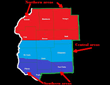
This weekend is looking like a home run if you like sunny skies and warm temps….This hold true right through much of Monday…..Monday night through Tuesday still up in the air to what will really take place…..1 Will there be a SFC low to form…2 or will there just be a long wave to move through…Why is this important? Well if a long wave moves through the area there will be a widespread chance of precip with snow in the North and rain snow mixed in my Central areas with mostly rain with some mix in my Southern areas…..Also noted precip would be lighter……If a low pressure forms this would allow for more of a confined areas of heavier precip in a smaller area….Looking at NAM model 12z runs more less show a long wave moving through, meanwhile GFS has a low pressure system forming over CO Sunday night/early Monday morning and moves it to Southeastern MN then through Central WI……If this pans out we could be dealing with more than a few inches of snow…..Looking at the ECMWF low forms just East of CO then is forecasted to move Northeast up into Southeastern MN then through Northeast WI into the UP of MI….This would give us more snow than GFS does and would give more of the FA more snow….Looking at a few other models best way to run is to blend most together. Big range in snow amounts 1 to 2 in my Southern areas.
1 to 3 in my Central areas…. 2 to 4 in my Northern areas….Seems to be the way to set this up for now… Will keep a chance of light snow going through the rest of this forecast cycle as it will really be hard to time short-waves dropping into the area…..

***YOUR SHORT AND MIDDLE TERM FORECAST***
TODAY… Cloudy.Still could see some flurries from time to time also could see some sun.Highs 32 to 36.
TONIGHT. Most cloudy. Lows 15 to 20.
SATURDAY. Mostly sunny. Highs 28 to 32.
SATURDAY NIGHT. Clear lows 12 to 17.
SUNDAY. Sunny. Highs 30 to 35.
SUNDAY NIGHT. Clear. Lows 19 to 23.
MONDAY. Partly cloudy, increasing clouds. Highs 34 to 38.
MONDAY NIGHT.Cloudy with snow…Rain and snow in central areas. Rain with a mix South. Lows 25 to 28.
TUESDAY. Cloudy. Snow.Highs 28 to 32.
TUEDAY NIGHT. Chance of light snow. Lows 20 to 25.
WEDNESDAY AND WEDNESDAY NIGHT. A slight chance of light snow. Highs 30 to 35. Lows 23 to 26.
THURSDAY AND THURSDAY NIGHT. A slight chance of light snow. Highs 30 to 34. Lows 20 to 25.

***LONG TERM FORECAST DISCUSSION 23rd through Mar 4th ***
Main story through this period will be temps and the possibility of a full blown winter storm on the 27 through the 29 time frame…..
GFS already has this low to far South on it latest runs once again….However our new model has the track from Western MO into Central WI before moving into Northeastern WI…. If this all plays out we should be dealing with a major snow storm….Most of the long term models have the same track…Will throw out GFS model…… Temps will start to cool off throughout this time frame…..

***YOUR LONG TERM FORECAST***
24TH. Dry highs 25 to 30 lows 15 to 20
25th. Dry highs 20 to 25 lows 5 to 15
26th. Dry highs 20 to 25 lows 10 to 20
27th. Snow highs 25 to 30 lows 17 to 23.
28th. Snow 20 to 25 falling… Lows -10 to -5
29th. Chance of snow highs 5 to 10 lows 0 to 5
1st. Chance of snow 20 to 25. Lows 10 to 15
2nd.Dry. highs 30 to 25 lows 15 to 20
3rd. Dry highs 25 to 30 Lows 15 to 20.
4th. Chance of snow highs 25 to 30 lows 15 to 20.

***THE EXTENEDED LONG TERM FORECAST DISCUSSION MARCH 5TH THROUGH MARCH 26TH ***
Overall looks like an active period ..With a chance of snow on the 5th and 6th. We do dry out for the 7th however another area of low pressure will effect the area on the 8th through 9th….High pressure builds back in for the 10th keeping us dry right through the 13th ….The 14th we will see a low pressure over in Southwestern ND move Southeast to Southern WI this should bring the FA another shot of snow from the 15th through the early 17th. Drying out later on the 17th should see the dry weather remain with us through 22nd. May be a chance at some sow on the 21th will run with dry for now…. 23rd another shot of snow comes into play….24th through the 26 looks to be dry….
As far as temps go…..Look for cold start, however temps do really warm up by the middle to the end of this period….In fact so much we may have to change some of the snow day to just plain old rain….Will worry about that at a later time……So most of March should bring us above normal percip, with normal to slightly above normal temps…

***NOTICE***
The extended long term forecast is an experimental product…This forecast can and almost sure it will change…..This product will not be issued every time we issue a forecast more less once a week or two….

Thursday, February 16, 2012

Updated News....

We did drop our two Northern Counties of Douglas and Bayfield from our FA....Once again Tim's weather blog has those Counties Covered....
Here is the map of our FA.
 Map below shows how our FA is divided up from Western through Eastern.The two maps below can also be found to the right...
 Map below shows how our FA is setup from Northern areas to Southern areas.

Ground breaking news at The Weather Center!

Once again The Weather Center is on ground breaking forecasts…We are happy to announce we will start bringing you a new product. As of right now our forecast goes out to 384 hours. This is called our long term forecast… Our new product will be called “The extended long term forecast”……This product will go out to 1092 hours in time….After spending the last few months studying this model... I’m happy to say we will start using it. Everything we have seen with this model has been close to if not right on track….Has a much better track record than GFS has in the middle and long term forecast, though we will still look at GFS model our long term will be geared more in line with this new model. In fact we have been using this model over GFS much of this winter, along with other long range models…..This model will also allow for us to give you our new product the longer term forecast……We are very excited about this….


Our Southwesterly neighboring blog Weather 4 You will also start to use this model as well …As Paul and I have spent countless hours/months studying this model.

In other news we may be dropping our far two Northern Counties that boarder Lake Superior, as Our Northwesterly neighboring blog, Tim’s Weather blog has those areas covered.

Another year without a spring?? could be.

Bad enough it was looking like another year without spring,then I read this and if this does happen no spring again this year,just like last year still had snow falling from the skies in May, and last year's so called spring was way below normal in the temp dept..Winter will make a come back and many won't like it!  All signs have been pointing to it for the last few weeks....Don't think it will be as cold as  -30 below, but it is possible.... Looks like our winter forecast could still be right on track..... Here is the a very interesting read.....Does look like they are buying into everything we have been saying for the last few weeks.... Sorry warm weather fans...You best had enjoyed the warmth we had and will have the rest of this week into much of next week, After that all bets are off.
http://science.nasa.gov/science-news/science-at-nasa/2012/16feb_deepfreeze/

A sight for sore eyes!

Pictures of convection type clouds today…A sure sign we are getting closer to spring…As a rule we don’t see this type of cloud formation until like the middle of March…..I have seen this one time in January years ago......


Pictures of last evening snows

Something I haven't really been doing a lot of,but will start once again...
This week (the week of the Feb 13th) we had picked up 2.25 inches of snow....The 13/14 was 1.25 inches. 15th we had 1.00 inches of snow.....Going back the 9th we picked up 1/2 the 10th we picked up 1.00.... So far this brings us to 3.75 inches of snow this month. At this time back in 2011 we have not had any snow > than 1/4 inch.....
The break down to this weeks snows so far...On the 13 we saw a weak area of low pressure pass to our South,meantime we also had a trof of low move in from the Northwest....There was a little more moisture with this system than thought.....Right on this system heals there was a Short-wave dropping out of ND into MN this moved into Southern Polk County then into Northern Dunn County before heading East/Southeast out of the FA....This Short-wave had enough lift and forcing to work with limited moisture to wring out a widespread 1/2 inch to 1.00 inch throughout much of my Central and into my Northern areas,meanwhile my Southern areas saw flurries that amounted to a dusting in a few areas.....


Friday, February 10, 2012

THe forecast for Western/Northwestern WI

Forecast problems….None…..Same old same old…..Only thing different is the cold air in place, but that should a no shocker as we forecasted that last Thursday.


***CURRENT CONDITIONS***
At Noon….Skies range from Sunny to cloudy across the area….Light snow/flurries have been ending….Temps range from 9 to 17 across the FA…..Winds have been gusting from 16 to 25 MPH…Here at the office winds have gusted up to 25 MPH also….

***SHORT TERM/MIDDLE TERM DISCUSSION***
Arctic cold front about ready to exit Southeast WI. Temps across Central and Northern MN are still at or below zero at this hour…..Likewise over in ND/Northern SD.
Light snow/flurries will becoming to an end as winds switch more to the Northwest…..Still some LES getting down into Northern parts of Barron and Rusk Counties as low level moisture streams off of Lake Superior….This has helped with snowfall totals….1.50 inches here at the office, 2.00 up in Haugen get into Rice Lake it’s self only a meager ¼ inch…
1043 Arctic high pressure is centered to our Northwest in Canada…This high is forecasted to drop South/Southeast throughout the day…Meanwhile a weak are of low pressure over Western MI is forecasted to Slowly Eastwards….Pressure gradients between these two systems will insure us of a breezy day and night along with a breezy Saturday……Winds combined with the air temps will send WCs down to the -5 to -10 today then we drop them lower for tonight -10 to -20…..Will hold on to the cold WCs right through Saturday night. Temps today won’t go much higher than they are, in fact should start to see temps tumble as we head through the afternoon.
Look for skies to have breaks here and there, before clearing out this evening. Should see a clearing work into the area within the next hour or so if winds do become more Northwest……Temps slowly warm on Sunday, should be right at normal….Monday through Thursday temps are forecasted to warm back above normal…..Still not too thrilled about snow chances for Monday and Monday night….Will run with a dry forecast for now……
Will see another dry week ahead next week.

***YOUR SHORT & MIDDLE TERM FORECAST***
REST OF TODAY…. Cloudy with some light snow/flurries ending, becoming clear in the afternoon. Highs middle teens then falling. Winds North becoming Northwest 10 to 20 MPH.

TONIGHT…. Clear cold, lows – 5 to – 15 Central and Northern areas. 0 to -5 Southern areas. Winds Northwest 10 to 20 MPH.

SATURDAY... Sunny cold highs single digits Central and North. 10 to 15 South. Winds Northwest 10 to 20 MPH.

SATURDAY NIGHT… Clear cold lows 0 to – 10 Central and North to 0 to 5 South.

SUNDAY... Sunny warmer highs 20 to 25.

SUNDAY NIGHT... Clear lows 5 to 10.

MONDAY…Cloudy dry highs 24 to 28

MONDAY NIGHT.. Cloudy dry lows 15 to 20.

TUESDAY THROUGH THURSDAY…. Dry highs in the middle 30s lows in the lower 20s.

***LONG TERM DISCUSSION FRIDAY 17TH THROUGH SUNDAY 26th ***
Another shot of cold air on tap for Next weekend…Will remain dry through the 19th a slight chance of snow for the 20th. Looks like a more significant snows for the 21st Will run with a chance of snow throughout the rest of the long term, as it will be too hard to pinpoint the timing of the systems.This time frame looks to be more active and colder as we head into the end of the month…Looks like the first to middle part of March will star in colder than normal temps with a better chance at seeing more snow…..Winter could be making a hard come back…..

Friday, February 3, 2012

Can you say dry weahter?

Forecast is rather dull, will be dry all the way through next Friday...No Big snow storms. no big heat waves, no big acrtic blast all of next week....Though temps do start to work their way down.By next Wednesday temps should be in the upper 20s.....Next weekend still looking cold and could be some snow late in the weekend.....More on all of that next week sometime.....Untill then enjoy the dry next week ahead....
Notice no forecasts will be issued untill there is something to talk about.....

Thursday, February 2, 2012

Colder air a coming!

Enjoy the warm weather some changes are coming in the weather pattern....Warm air will hang around through about the first part to maybe to middle part of next week....After that cold air if forecasted to drain into the area....Could be cold enough to put temps back to below zero by next weekend....Still a few things that need to be worked out, however all signs have been pointing to this change for the last week in a half now.....
Looks like the rest of this week will remain warm and dry...Tonight fog is a likely bet once again...Could be freezing for around also.....Temps should range from the middle 30s to middle 40s across the area...Cooler were there is still a snow pack....First cold front blasts through the area on Monday late afternoon early evening...This will throw temps back below 32....Stronger Arctic cold front races through sometime next Thursday... The real bitter cold air should arrive next Friday/ Friday night's frame......Next weekend looks cold! There are some hints at a possible snow storm by next weekend.....Welcome back to winter at end of next week!!!

Wednesday, February 1, 2012

Time to look back at January 2012

This info come from The Weather Center's office....
Looking back at January 2012…
January was a rather warm month…However did have two nights were temps did fall to 20 below and a few other nights were temps were below zero…Two days temps never got a bove 0 for highs….So when we average this all out temps will average to slighly above normal here at the office….Down in my Southern zones temps were much above normal….

We had 10 snow days….Day on which snow of > than 0.25 inches had fallen.

01/01 we had 6.00 inches of snow.

01/11 and01/12 two day total was 3.75 inches of snow.

01/18 we had 1.50 inches of snow.

01/23 we had 4.50 inches of snow.

01/24 and 01/25 two day total was 3.25 inches of snow.

01/27 we had 2.75 inches of snow.

01/30 we had 1.00 inches of snow.

This gives us a total of 22.75 inches of snow for this month….

January 2011 we had 22.50 inches of snow…So this year and last year we neck in neck of snowfall totals. 2012 just above last year's reading......