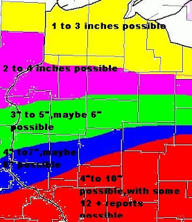
Looking at this morning's 0z computer models runs, we find a lot of interesting stories from them...So lets break this down model by model,however before I get to that let me say this storm system is a pain since day one when it showed up on the models...Remind everyone.This storm is not even in the USA right now...It's coming together near the British Columbia coast line...
Ok let talk about the ECMWF model...The track of the storm per this model really hasn't changed from day one...Low pressure of 983 MBS is centered over Northeast CO/far Southwest NE..The low is forecasted to move Northeast toward North Central WI to around the City of Park Falls...So far this has been about the same track ECMWF has been yelling over the last several days....So if this does pan out we could be getting some accumulating snows,however most of the heavy snow will be in my Northern Counties...Still this area would be dealing with snow/rain mix until around late Saturday night into Sunday morning which would hold down the amounts to some degree...Nevertheless we would see accumulating snows....Winds will also increase on Sunday as pressure gradients really tighten up behind a strong cold front....
Ok now lets talk about the GFS model...
GFS showing the low pressure of 985 MBS in Northeast WY and it drops it South to almost the TX Panhandle..GFS then ejects the low into Southern MN then Northeast to around the city of Superior...This track did shift a little East than yesterday(not by much,but still did shift)..Now if this model pans out most of the WI forecast area would be dealing with snow/rain mix with some freezing rain as warmer air would have more time to work into the area,before it all changes over to all snow on Sunday...Most of the heavy snow would be in over in North Central and Northern MN while Northwest WI would pick up some accumulating snows,while Western WI would barley see anything(less amount of snow)
Lets talk about the NAM model....
Nam has the low pressure over Central CO and has it's pressure around 988 MBS,Nam moves the low into Northern KS,Then shapely ejects into Southern MN then along the WI/MN border.Before moving it into the UP of MI,What is interesting here is SFC temps warm up to around the middle 30s to lower 40s...So this model would support mainly rain..With rain mixing with snow early Sunday,before changing to all snow Sunday afternoon,After a strong cold front slams through the area...Now looking at the winter critical thickness values...We see there is some arguments showing up between all levels,not much but still enough to be consered about rain vs snow.....
Ok what models do we use and what models to throw out or do we blend them?
I will use ECMWF and will blend in GFS along with some of it's members of NAM....
Saturday a warm front will blast through the area by 12z we should see a mix of light rain and snow..Soundings also showing this rather well,still a little concerned about some freezing light rain Saturday afternoon into the evening hours..We also see a cold front moving into Northwestern MN at the same time frame...By Sunday 00z we see the clod front reaching from Northeast MN back towards CO..There is also a trof forming over Central MN.By 12z Sunday the 990 MB low is forecasted to be over Eastern NE/Western IA..By 12z Monday the low should be over North Central WI,as it moves to this area the low will slam a strong Arctic cold front into and through the area..So any mixed precip will change over to all snow..Now depending on where the dry slot sets up and how strong it is, along with the deformation zone...Will depend how much snow will fall across WI...As of right now I think the heaviest snows will fall across MN,However Northwest could see 6 plus inches,while Western WI could see 4 inches plus....This will all depend on the final out come of the storm track which is still some what up in the air...I still like the track that takes the low from IA into North Central WI...This would change the mix precip over faster and give Northwestern and West Central WI a good deal of snow.....I see the HPC is also in agreement with that track....We will watch this through out the day...Will have updated forecast through out the day and into tonight,as this is all in the forming stages...Anything is still possible at this point in time....Stay tuned for more updates as we head through the day and into tonight as we get a better handle on this possible major snow storm for Northwestern and Western WI FA...


 Dark blue area on map is 2 to close to 3 inch mark...

