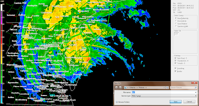
Tropical storm Irene still pounding the Eastern Coast line..
Flooding rains heading North of New York City…..Major flooding has been occurring in the Northeast overnight.
The main player was and still is the major flooding….There was also damaging winds and a few tornadoes were reported overnight….Major beach erosion up and down the Eastern Coast line…Major inland flooding still happen as heavy rain keeps pounding the Northeastern States… Coast line areas for the most part seems to done with the major flooding storm surge is now over….Most concerns are now focused inland with the major flooding….Many roads are impassable….Many rivers will be cresting within the next 24 hours…..
Good news with hurricane Irene the storm surge and high tide really didn’t join forces …..
Main concerns now shift to MA Up State NY, VT,NH….. These areas should see major flooding throughout the day.Still should see Coastal flooding in these area also...
We are still trying to figure out if the storm made landfall in NY as a hurricane or a tropical storm….As of right now Irene is a Tropical storm…..
The last update we got from the NHC as of 8:00 AM EDT.
Irene was a Cat 1 hurricane….(this is now a Tropical storm)
The center was 40 Miles South/Southwest of NYC…( has made landfall)
Pressure was 963 MB…
Drier air has worked its way into the Southern areas of Tropical storm Irene…The heavy rain should be ending in NYC soon…
Heavy rain will keep pounding areas North of NYC/Long Island…..
Tropical Storm Irene is still a dangerous storms…There will be strong winds with trees getting blown down along with more power outages….Main threat will be the major flooding…..
2 million people still without power….However power is slowly being restored….
At least 10 related deaths….
This will be the last update from The Weather Center……
Here are some radar grabs mainly from last night…
Here is the latest satellite imagery.
Moonshot
7 months ago


