Severe weather pounded parts of our FA on Sunday May 22nd…Many hail reports will only list 1” or > since that is the severe weather threshold…6 tornadoes have been confirmed be the NWS offices of Chanhassen and Duluth.
First off lets list the hail damage…
Once again we are only going to list > one inch or greater…There were 9 hail reports …Notice times are not in order…This info comes from the LSR from both Chanhassen and Duluth NWS.
1. 4NW of Elmwood in Pierce Cnty@3:12 PM
2. 1.50” 3W of Elmwood in Pierce Cnty@3:14 PM
3. 1.75” Elmwood in Pierce CNTY@3:15 PM
4. 1.00” 2S of Chippewa Falls in Chippewa Cnty@4:07 PM
5. 1.00” 9S/SE of Loretta in Sawyer Cnty@2:25 PM
6. 1.25” 7S/SE of Loretta in Sawyer Cnty@2:25 PM
7. 1.00” 3N of Butternut in Ashland Cnty@3:04 PM
8. 1.00” 6S/W of Butternut in Ashland Cnty@3:23 PM
9. 1.50” 2S of Kennan in Price Cnty@5:33 PM
There was 12 thunderstorm wind damage reports. List is not in any order.
1. 13W of Phillips in Price Cnty@2:35 PM
2. 13W/NW of Phillips in Price Cnty@2:38 PM
3. 2NW of Park Falls in Price Cnty@3:04 PM
4. 2SE of Butternut in Ashland Cnty@3:15 PM
5. 10NE of Butternut in Ashland Cnty@3:57 PM
6. 2NW if Mikana in Barron Cnty@4:00 PM
7. 2N of Mercer in Iron Cnty@
8. Counderay in Sawyer Cnty@4:27 PM
9. 8E of Phillips in Price Cnty@6:13 PM
10. 1NE of Phillips in Price Cnty@6:13 PM
11. Loretta in Sawyer Cnty@5:18 PM
12. 2NE of Stone Lake in Sawyer Cnty@4:27 PM
There was 6 confirmed tornadoes to effect the FA.
1. 2NW of Mikana in Barron Cnty rated low end EF1. time of tornado @4:00 PM
2. 12SW of Park Fall in Price Cnty rated low end EF1 time of tornado @ 2:33 PM
3. 4.5 W of Prentice in Price Cnty rated EF0. time of tornado @ 5:39 PM
4. 4N/NW of prentice in Price Cnty rated EF0 time of tornado @5:52 PM
5. 6.5 E/SE of Phillips in Price Cnty rated EF0 time of tornado @6:01 PM
6. 17 NE of Phillips in Price Cnty rated EF0 @ time of tornado 6:26 PM
Once again all the above info comes from the LSRs from both Chanhassen and Duluth NWS…All info is preliminary.
For the pictures of the storm that produced the tornado see below….Now on to some damage pictures.
The images below are from the base reflectivity as the storms moved through Barron County.
Images below are the storm relative volocity scans as the storms plowed through Barron County.
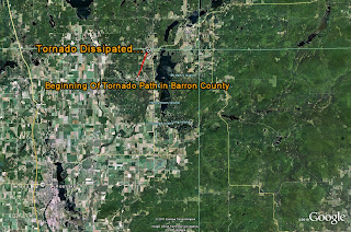
Many tress were also downed in the city of Rice Lake it's self...The image below is from the NWS showing the start and end track of the tornado.
The day started off with thunderstorms during the early morning hours,then there was a break in the action...Sun was able to peak out for a time,which was enough to get some SFC heating going..With the very cold air aloft did take much to fire up storms...Also had a warm front through the area and a SFC low pressure system over in Central MN which also worked East...This pushed a cold front into the area causing lift to keep the updrafts alive...Wind shear was off the charts around 30 KTS plus.These storms also produced flooding rains throughout much of Barron County and points towards the North/Northeast.
Click on pictures to see a bigger size....
Moonshot
7 months ago


